PAS 150 Aerial Camera System
The most compact solution for aerial mapping
Fully integrated system
The 150MP Aerial System (PAS 150) is based on the iXM-RS150F cameras. The system comes ready to work with a fully integrated iX Controller, stabilizer mount, and IMU unit.
150MP Aerial System
The 150MP Aerial Systems are fully integrated solutions based on the iXM-RS150F high-resolution metric cameras. Each aerial solution includes a camera, iX Controller with integrated Applanix GNSS-Inertial, Somag stabilizer, IMU unit, and Phase One flight planning and management software – iX Plan, iX Flight Pro, and iX Process.
- Fully integrated Phase One Aerial System
- Large image coverage
- Exceptional accuracy and image quality
- Optional 4-Band configuration with dual frame sensors for RGB and NIR imaging
- Lightweight & low power
4-band configuration
The 4-band configuration is comprised of RGB and Achromatic cameras, with which images are captured in RGB and NIR bands simultaneously. Data is then processed automatically to generate distortion-free images and co-registration of the NIR pixels with the RGB is performed.
This function is extremely useful for remote sensing and mapping applications in the fields of agriculture, forestry and environment monitoring.
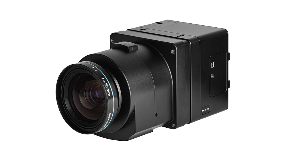
iXM-RS150F Aerial Cameras
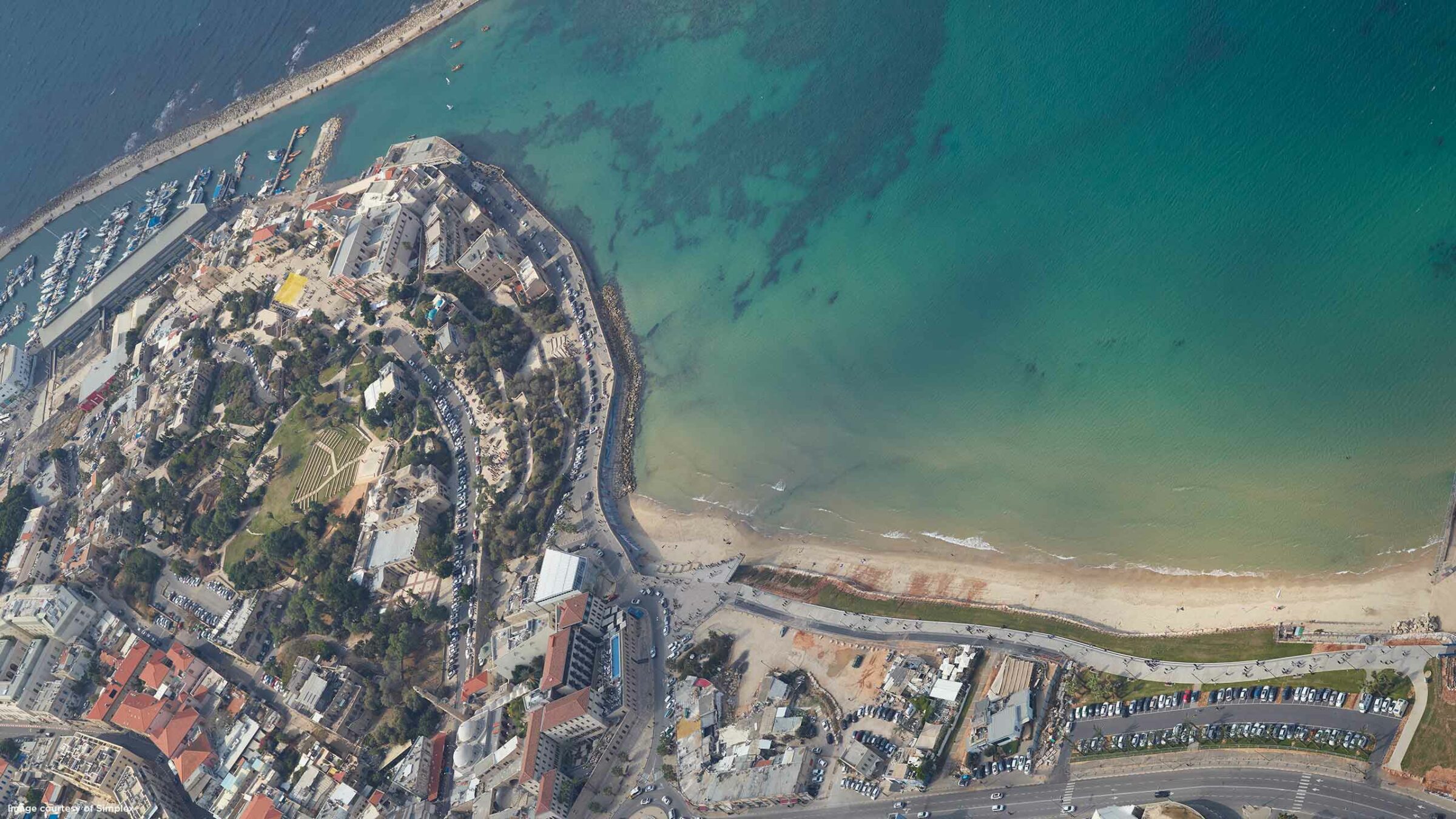
iXM-RS150F is equipped with a full frame sensor (14204 x 10652 pixels), and a 3.76-micrometer pixel size to enable higher ground resolution from a greater flight altitude. It provides larger aerial coverage resulting in improved aerial survey productivity.
The camera comes with one of eight RS lenses ranging from 32mm to 180mm focal length, and the 300mm RSM lens. All lenses are equipped with a central leaf shutter to ensure geometrically correct aerial images.
- BSI CMOS sensor
- High dynamic range of 83 dB
- Fast image capture rate of 2 frames per second
- Recommended for high quality
- 3D city models
IX CONTROLLER
The iX Controller, with integrated GNSS-Intertial, acts as a central hub for Phase One Aerial Systems and operates the cameras, gyro-stabilizing mount, IMU system, and runs iX Capture and iX Flight software.
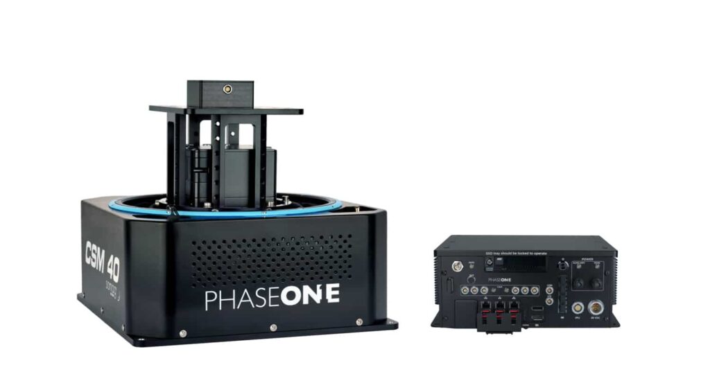
SOMAG GYRO-STABILIZED MOUNT (CSM40)
A small modular stabilization device that was specifically designed for the Phase One 150MP/ 100MP Aerial Solutions. With a low weight of 5.2 kg and a high payload of 15 kg, the special mount system is particularly suitable for ultralight aircraft.
GNSS/IMU system
The Phase One 150MP Aerial Systems are available with different GNSS and IMU configurations to meet your application and accuracy levels requirements.
Download brochure for specifications >
Monitors for PAS solution
Phase One provides a complete solution for the PAS product line offering two operating monitors, 15’’ and 21’’, and one 7” pilot monitor fitting all PAS systems. The monitors are ruggedized displays tailored for airborne applications. All monitors are Phase One branded and tested on our PAS offerings.
iX Suite - Software
Seamless workflow, quality assured from the earliest stage
Experience streamlined mission planning with iX Plan—initiate planning by selecting your Phase One system, automatically generating flight lines and controlling project costs. Elevate your mapping project with iX Flight Pro, ensuring precise mission execution and increased efficiency with instant images review and replan while flying. Streamline your workflow with iX Process for immediate image review and adjustments without need of pre-processing.
-
PAS 150
150MP Aerial System
The 150MP Aerial Systems are fully integrated solutions based on the iXM-RS150F high-resolution metric cameras. Each aerial solution includes a camera, iX Controller with integrated Applanix GNSS-Inertial, Somag stabilizer, IMU unit, and Phase One flight planning and management software – iX Plan, iX Flight Pro, and iX Process.
- Fully integrated Phase One Aerial System
- Large image coverage
- Exceptional accuracy and image quality
- Optional 4-Band configuration with dual frame sensors for RGB and NIR imaging
- Lightweight & low power
-
4-band configuration
4-band configuration
The 4-band configuration is comprised of RGB and Achromatic cameras, with which images are captured in RGB and NIR bands simultaneously. Data is then processed automatically to generate distortion-free images and co-registration of the NIR pixels with the RGB is performed.
This function is extremely useful for remote sensing and mapping applications in the fields of agriculture, forestry and environment monitoring.
-
iXM-RS150F Aerial Cameras
iXM-RS150F Aerial Cameras
iXM-RS150F is equipped with a full frame sensor (14204 x 10652 pixels), and a 3.76-micrometer pixel size to enable higher ground resolution from a greater flight altitude. It provides larger aerial coverage resulting in improved aerial survey productivity.
The camera comes with one of eight RS lenses ranging from 32mm to 180mm focal length, and the 300mm RSM lens. All lenses are equipped with a central leaf shutter to ensure geometrically correct aerial images.
- BSI CMOS sensor
- High dynamic range of 83 dB
- Fast image capture rate of 2 frames per second
- Recommended for high quality
- 3D city models
-
Additional hardware
IX CONTROLLER
The iX Controller, with integrated GNSS-Intertial, acts as a central hub for Phase One Aerial Systems and operates the cameras, gyro-stabilizing mount, IMU system, and runs iX Capture and iX Flight software.
SOMAG GYRO-STABILIZED MOUNT (CSM40)
A small modular stabilization device that was specifically designed for the Phase One 150MP/ 100MP Aerial Solutions. With a low weight of 5.2 kg and a high payload of 15 kg, the special mount system is particularly suitable for ultralight aircraft.
GNSS/IMU system
The Phase One 150MP Aerial Systems are available with different GNSS and IMU configurations to meet your application and accuracy levels requirements.
Download brochure for specifications >
Monitors for PAS solution
Phase One provides a complete solution for the PAS product line offering two operating monitors, 15’’ and 21’’, and one 7” pilot monitor fitting all PAS systems. The monitors are ruggedized displays tailored for airborne applications. All monitors are Phase One branded and tested on our PAS offerings.
-
iX Suite - Software
iX Suite - Software
Seamless workflow, quality assured from the earliest stage
Experience streamlined mission planning with iX Plan—initiate planning by selecting your Phase One system, automatically generating flight lines and controlling project costs. Elevate your mapping project with iX Flight Pro, ensuring precise mission execution and increased efficiency with instant images review and replan while flying. Streamline your workflow with iX Process for immediate image review and adjustments without need of pre-processing.
Upgrading to Phase One next-generation systems has improved our quality, timeliness, and made both our collection and processing more efficient and streamlined. The investment has been well worth the return
Logan Hancock
Vice President Imagery Solutions - Eagle Forestry Services, Inc.
Technical specifications
Specifications
PAS 150
Cameras (Nadir)
150MP RGB camera with a variety of lens options
Cameras (Nadir)
150MP RGB camera with a variety of lens options
150MP NIR camera (optional)
150MP NIR camera (optional)
Pixel swath
14,204
Pixel swath
14,204
Frame size (Nadir)
14,204 x 10,652 pixels (RGB)
Frame size (Nadir)
14,204 x 10,652 pixels (RGB)
14,204 x 10,652 pixels (NIR)
14,204 x 10,652 pixels (NIR)
Coverage (Nadir)
5 cm GSD: 0.38 km2 footprint area
Coverage (Nadir)
5 cm GSD: 0.38 km2 footprint area
10 cm GSD: 1.51 km2 footprint area
10 cm GSD: 1.51 km2 footprint area
20 cm GSD: 6.05 km2 footprint area
20 cm GSD: 6.05 km2 footprint area
Frames per second
2
Frames per second
2
Dynamic range (dB)
83
Dynamic range (dB)
83
Channels
RGB, NIR optional
Channels
RGB, NIR optional
Power consumption
110W
Power consumption
110W
160W max peak power
160W max peak power
System weight (kg/Lb)
8.5 / 19
System weight (kg/Lb)
8.5 / 19
Dimensions (mm/in)
290 x 275 x 121 / 11.4 x 10.8 x 4.7
Dimensions (mm/in)
290 x 275 x 121 / 11.4 x 10.8 x 4.7
Data storage capacity (Controller)
4 TB or 8 TB
Data storage capacity (Controller)
4 TB or 8 TB
64 GB RAM
64 GB RAM
Stabilized mount
Somag gyro-stabilized mount CSM 40 or DSM 400
Stabilized mount
Somag gyro-stabilized mount CSM 40 or DSM 400
Mount weight (kg/Lb)
5.2 / 11.5
Mount weight (kg/Lb)
5.2 / 11.5
GNSS/IMU
iX Controller with integrated Applanix GNSS-Inertial
GNSS/IMU
iX Controller with integrated Applanix GNSS-Inertial
AP180 (IMU – 69/79)
AP180 (IMU – 69/79)
AP310 (IMU - 93)
AP310 (IMU - 93)
AP510 (IMU - 95)
AP510 (IMU - 95)
AP610 (IMU - 57)
AP610 (IMU - 57)
Field of view (RGB/NIR)
PAS 150
40 mm
53.2 ° along track, 67.5 ° across track
40 mm
53.2 ° along track, 67.5 ° across track
50 mm
43.7 ° along track, 56.2 ° across track
50 mm
43.7 ° along track, 56.2 ° across track
70 mm
31.9 ° along track, 41.8 ° across track
70 mm
31.9 ° along track, 41.8 ° across track
90 mm
25.1 ° along track, 33.1 ° across track
90 mm
25.1 ° along track, 33.1 ° across track
110 mm
20.6 ° along track, 27.3 ° across track
110 mm
20.6 ° along track, 27.3 ° across track
150 mm
15.2 ° along track, 20.2 ° across track
150 mm
15.2 ° along track, 20.2 ° across track
180 mm
12.7 ° along track, 16.9° across track
180 mm
12.7 ° along track, 16.9° across track
Ready to take the next step?
Whether you have questions about our solutions or need more information, our sales team is ready to guide you along the process and answer any questions you may have.
Book a meeting with our team today.
Need support for an existing product or service?
Please visit our Support Page for faster assistance.