Eight perspectives, one system
Redefining cost-efficient oblique imaging for next-generation 3D reconstruction
Customer snapshot
Who: GGS, a German aerial surveying integrator focused on high-resolution photogrammetry and 3D city modeling systems.
Challenge: Deliver high-quality oblique datasets for 3D reconstruction while reducing hardware complexity, purchasing and acquisition costs — without compromising geometric accuracy.
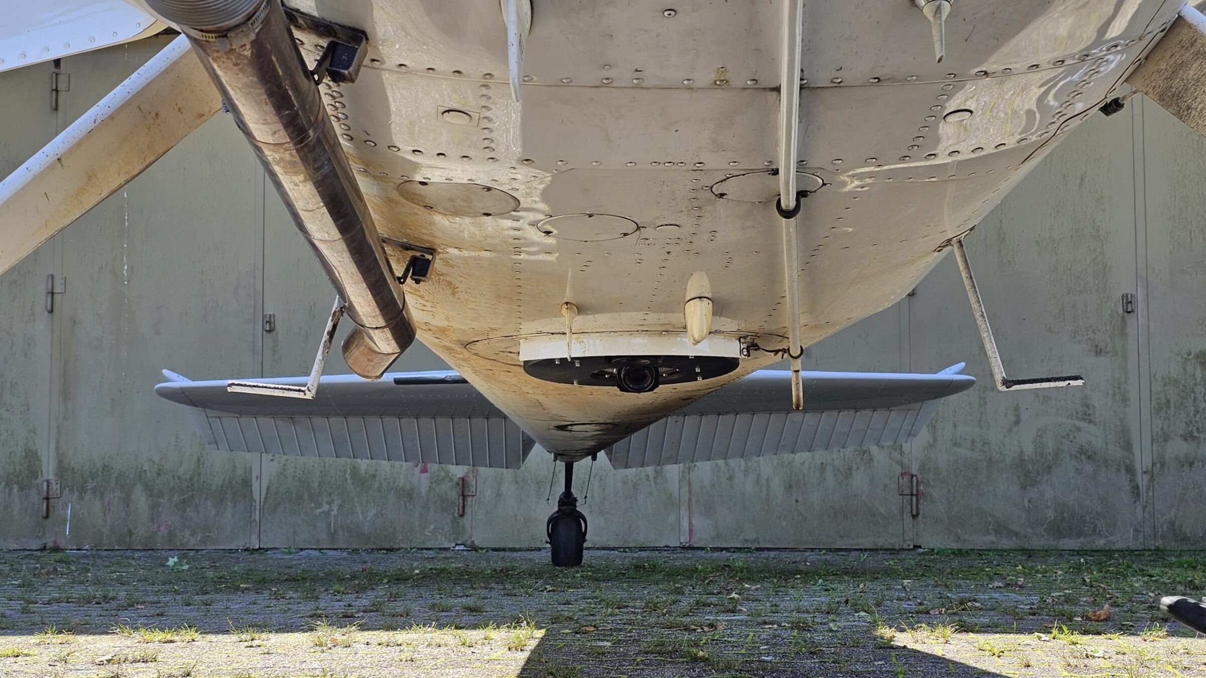
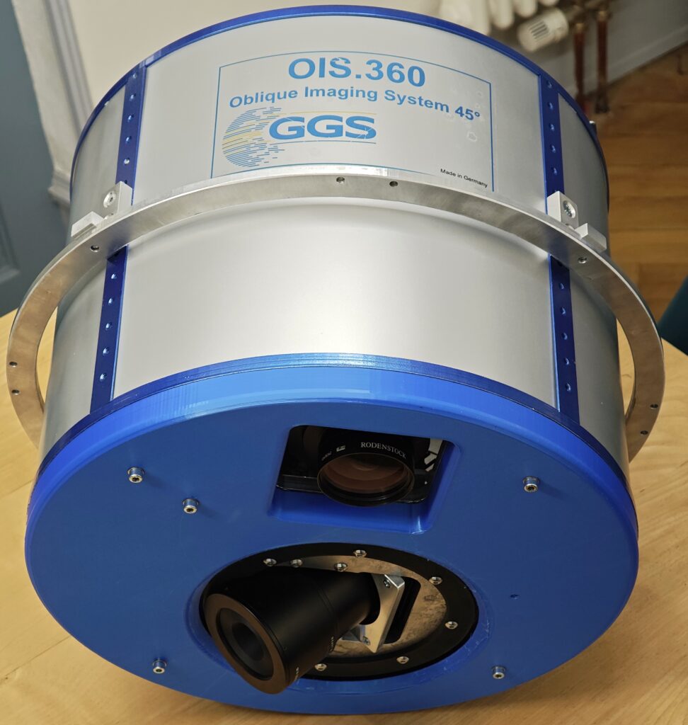
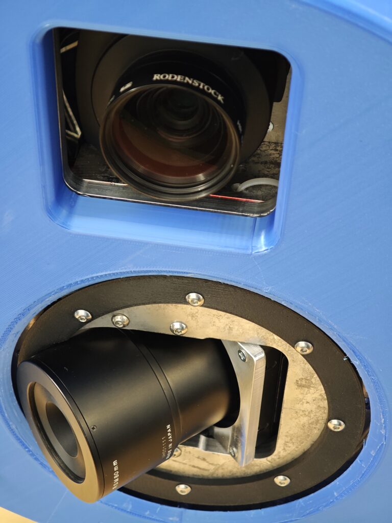
Solution: Deployment and validation of the OIS.360 imaging system: a two-camera configuration combining a nadir sensor with a rotating oblique camera capturing eight perspectives.
Result: Aerotriangulation accuracy comparable to classic five-camera systems, strong 3D reconstruction performance, and measurable cost and integration advantages — with added benefits for Gaussian splatting workflows.
Industry context: why this matters now
Demand for detailed 3D city models and digital twins continues to accelerate. Municipalities, infrastructure operators, and engineering firms require higher resolution, better façade representation, and reliable geometric accuracy — often under increasing cost pressure.
At the same time, reconstruction workflows are evolving. Techniques such as Gaussian splatting are gaining attention because they leverage multi-view imagery more efficiently than traditional mesh-only approaches. These methods benefit from increased perspective diversity rather than simply higher pixel counts.
Conventional oblique systems typically rely on five synchronized cameras — one nadir and four fixed obliques. While proven, these systems are mechanically complex, costly, and introduce multiple internal orientations that must be calibrated and maintained.
The question GGS set out to answer was straightforward:
Is it possible to simplify the hardware architecture while maintaining — or even enhancing — reconstruction quality?
While multi-camera systems remain the standard for many high-end applications, GGS explored whether a simpler architecture could deliver comparable results in specific use cases.
Global shutter as a system enabler
At the core of this approach is high-speed global shutter imaging. Capturing multiple perspectives within seconds—at full resolution—requires precise, distortion-free exposure, ultra-high framerate under extreme mechanical conditions.
The use of a high-resolution global shutter sensor ensures:
• A frame rate (fps) of up to 5 frames per second, validated in testing with 180 ms capture intervals across 300+ sequential images.
• Distortion-free capture under aircraft motion
• Precise and repeatable exposure timing
• Consistent geometry across sequential images
• Cost saving on shutter maintenance due to shutterless operation.
This level of temporal and geometric consistency is essential when capturing multiple viewpoints in rapid succession—and enables system architectures that would be difficult to achieve with rolling or central leaf shutter technologies.
A new approach: complementing traditional systems with angular diversity
Instead of increasing the number of sensors, the OIS.360 system focuses on perspective diversity.
The configuration combines:
- A high-resolution nadir camera (also as 4 band system)
- A rotating oblique camera capturing eight perspectives per cycle
Within a few seconds, the system collects a full set of oblique views at different angles—delivering rich multi-view geometry with only two cameras.
“The key challenge was balancing speed with absolute stability during capture,” explains the engineering team. “Each image must be taken in a static position relative to the system frame to maintain geometric integrity.”
With two cameras instead of five, calibration is simplified while viewpoint diversity is preserved and in some cases enhanced.
Additionally, the use of electronic global shutter exposure avoids high‑frequency mechanical shutter wear, allowing a single rotating oblique camera to reliably capture multiple perspectives per cycle while reducing long‑term maintenance requirements.
The key challenge was balancing speed with absolute stability during capture. Each image must be taken in a static position relative to the system frame to maintain geometric integrity.
Proven in the field: validation through real flight campaigns
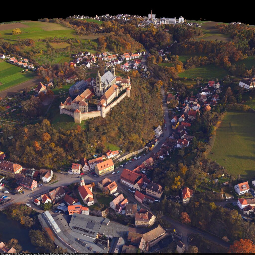
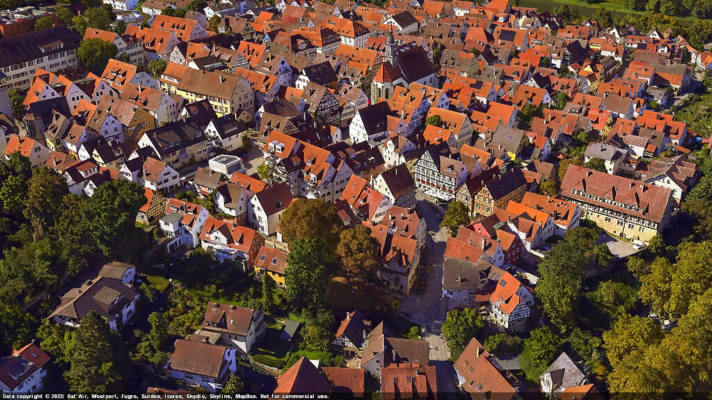
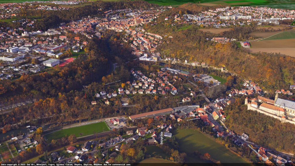
GGS validated the system across multiple flight campaigns over urban environments in southern Germany.
Processing was carried out using industry-standard tools including Skyline PhotoMesh, Pix4D and Bingo.
The results were clear:
~0.4 px accuracy using four oblique views + nadir (comparable to established oblique system configurations)
~0.32 px accuracy using all eight perspectives + nadir
Stable calibration across all datasets
Even under challenging conditions—low sun angles, strong shadows, and irregular flight lines—the system maintained consistent reconstruction quality across façades and rooftops.
These results demonstrate that alternative system architectures can achieve competitive performance under the tested conditions.
Designed for emerging reconstruction workflows
Beyond traditional photogrammetry, the system was also evaluated in Gaussian splatting workflows—an emerging approach that relies heavily on dense multi-view consistency.
Here, the ability to capture multiple perspectives in rapid sequence becomes particularly valuable.
In testing, the dataset showed clear advantages in:
• Thin structure reconstruction
• Edge continuity
• Complex facade detail
This highlights an important shift: reconstruction quality is increasingly influenced by viewpoint diversity and temporal consistency—areas where high-speed global shutter capture plays a critical role.
Why perspective matters: advantages in modern reconstruction workflows
As reconstruction pipelines evolve, angular diversity is becoming increasingly important alongside sensor configuration.
This was particularly evident in Gaussian splatting workflows, where the system showed clear benefits:
- Improved reconstruction of thin structures
- Sharper edges and façade details
- Better continuity across complex geometry
While traditional mesh outputs remained slightly sharper at close range, splat-based reconstructions demonstrated strong overall structural clarity.
In certain workflows, increased perspective diversity can complement—or in some cases rival—traditional multi-camera configurations.
The optimal approach ultimately depends on project requirements, scale, and desired output formats.
Operational impact: simplifying without compromise
Beyond technical validation, the system delivered measurable operational benefits:
- Reduced hardware complexity – fewer cameras required compared to traditional multi-camera setups
- Lower acquisition cost – significantly reduced system investment
- Simplified calibration – fewer internal orientations to manage
- Competitive accuracy – matching established oblique systems
- Future-ready workflows – aligned with emerging multi-view reconstruction methods
Importantly, the sequential capture approach did not introduce measurable gaps or degradation in data quality at tested resolutions at 4 cm GSD.
Multi-camera systems continue to play a critical role in large-scale and high-end mapping projects. The approach presented here expands the range of available solutions rather than replacing existing ones.

A scalable architecture for the future
The OIS.360 system demonstrates that innovation in aerial imaging does not necessarily come from adding more hardware—but rather from rethinking how data is captured.
With planned GNSS-IMU integration and further optimization of capture cycles, the system is expected to support even higher accuracy and smaller GSDs.
Tuning the global shutter technology e.g. with shutter fusion for higher frame rates will push forward to better GSD. That way a full image sequence can be reduced to 1.5 sec which would allow 2-3 cm GSD. Also, the new lens series that will come up will give more flexibility in setups as well as new global shutter sensors of 150 MP or higher.
Rather than scaling through additional sensors, the architecture evolves through software, control, and geometry—making it inherently adaptable to future workflows.
Rethinking how aerial data is captured
By introducing an alternative to multiple fixed cameras, GGS has shown that it is possible to simplify system design while maintaining high-end performance.
In a market increasingly driven by efficiency and data quality, this approach highlights a potential shift in how aerial data can be captured for next-generation 3D reconstruction.
About GGS
GGS is a German aerial system integrator specializing in high-resolution photogrammetry, oblique imaging, and digital twin technology. The company focuses on operational validation and practical implementation of emerging imaging technologies within professional mapping environments for the benefits of its customers. With more than 30 years of expertise, GGS has customers around the world.

Geospatial
Finding tiny cracks with UAVs opens new opportunities

Geospatial
From capture to corridor intelligence: How Kavel 10 scaled 1 cm mapping with the Phase One + IGI CM-1

Geospatial
From sensors to solutions: How AISPECO orchestrates precision in reality surveying

Geospatial
Monitoring pipeline corridor using PAS 280 large format camera

Geospatial
Preventing Wild Bushfires By Mapping Planned Burns

Geospatial
Novice Aerial Photographer Becomes Advanced Mapping Provider

Geospatial
Inspecting Wind Turbine Blades While They Are Rotating

Geospatial
Precision at Altitude: Redefining Aerial Mapping with the PAS 880 Oblique Camera System

Geospatial
Perfecting telescope dish accuracy with UAV photogrammetry

Geospatial
Saving costs while lowering carbon footprint: Innovative aerial surveying service uses small airplanes enabled by compact cameras

Geospatial
Detecting forest tree diseases using a large-format camera on an ultralight aircraft

Geospatial
Mapping lava flows during volcanic eruptions in Iceland

Geospatial
The PAS Pana: a 48,800-pixel camera innovated with our customer Surdex

Geospatial
Rebuilding after Hawaii’s wildfire with engineering-grade surveying

Geospatial
Revolutionizing Slovenian urban planning: Phase One’s PAS 880i redefines reality mapping