Detecting forest tree diseases using a large-format camera on an ultralight aircraft
AlterGeo efficiently locates individual parasite infestations over a large area of Polish forest canopy and assesses tree damage, using a PAS 280 photogrammetric camera.
The challenge
The infection of trees by fir mistletoe (Viscum album) leads to their gradual demise and rapid decomposition. It is a significant concern for forest management in Poland, where widespread mistletoe has led to extensive forest dieback, releasing carbon dioxide and affecting the timber industry.
However, evaluating the extent of mistletoe infestations in large forests and documenting its effects on individual trees has been a laborious and slow process. Mistletoe blends into the tree’s foliage, making it difficult to find and correlate with the health of the particular tree.
With large areas to cover, AlterGeo sought to use high-resolution aerial photogrammetry to precisely identify tree species and other forest stand parameters, facilitating efficient mapping of forest areas at a rate of approximately 4,000 hectares per hour.
This approach has proven highly productive for forest management, being 50 to 100 times more efficient at data acquisition compared to drone-based methods with similar parameters.
The Phase One 280 Aerial System installed on Alter-Eye is an unprecedented combination of a light aircraft with a large format camera with a stabilizing mount. It brings you effective way to extend your fleet, provides you the highest image capture, and dynamic range, elevating the quality and accuracy of your final photogrammetric products.
Applying advanced aerial photography to environmental phenomena
Aerial photogrammetry is primarily used to create topographic maps and document anthropogenic features such as buildings, roads, railway lines, and agricultural fields. The method has supplanted the labor-intensive process of field measurements. However, the detection and mapping of environmental phenomena has had a secondary role in photogrammetry, leading to the emergence of an insular set of standards and technical conditions. These traditional products do not meet the demands of contemporary forest management.
AlterGeo Holding, a company specializing in the integration of environmental remote sensing devices on ultralight aircraft, successfully tested the Phase One PAS 280 large-format photogrammetric camera to detect trees infected by the mistletoe hemiparasite (Viscum album). This hemiparasite, resembling a shrub and ranging in size from several centimeters to several dozen centimeters, grows into the wood of tree branches. It exploits the tree’s biological resources by using the water transported through the wood, and its leaves compete with the tree’s leaves for sunlight. Because mistletoe is green and blends into the tree’s foliage, it is relatively difficult to visually isolate in images of the tree.
Long-term infection by mistletoe leads to the slow death of trees, a process accelerated by global warming and water shortages. Dying trees slow down the assimilation of carbon dioxide and release large amounts of it into the atmosphere as they decompose. Polish foresters are increasingly worried about the effects on climate protection efforts to mitigate the effects of global warming, and on the timber industry, which helps reduce the use of plastics and synthetic materials.
To detect a parasite no larger than a branch, photos were taken with an extremely high resolution, with a Ground Sample Distance (GSD) of 2 cm, which is typically not achievable from the traditional heights of aerial photography.
The Alter-Eye plane successfully addressed this challenge with its excellent flight characteristics and large payload capacity for sensors.
As Antoni Łabaj CEO of AlterGeo Holding says, “The combination of low flight speeds at low altitudes and the large image scene provided by the PAS 280 camera enabled us to plan flights with a high longitudinal photo coverage of 60%, resulting in excellent quality aerial photography.”
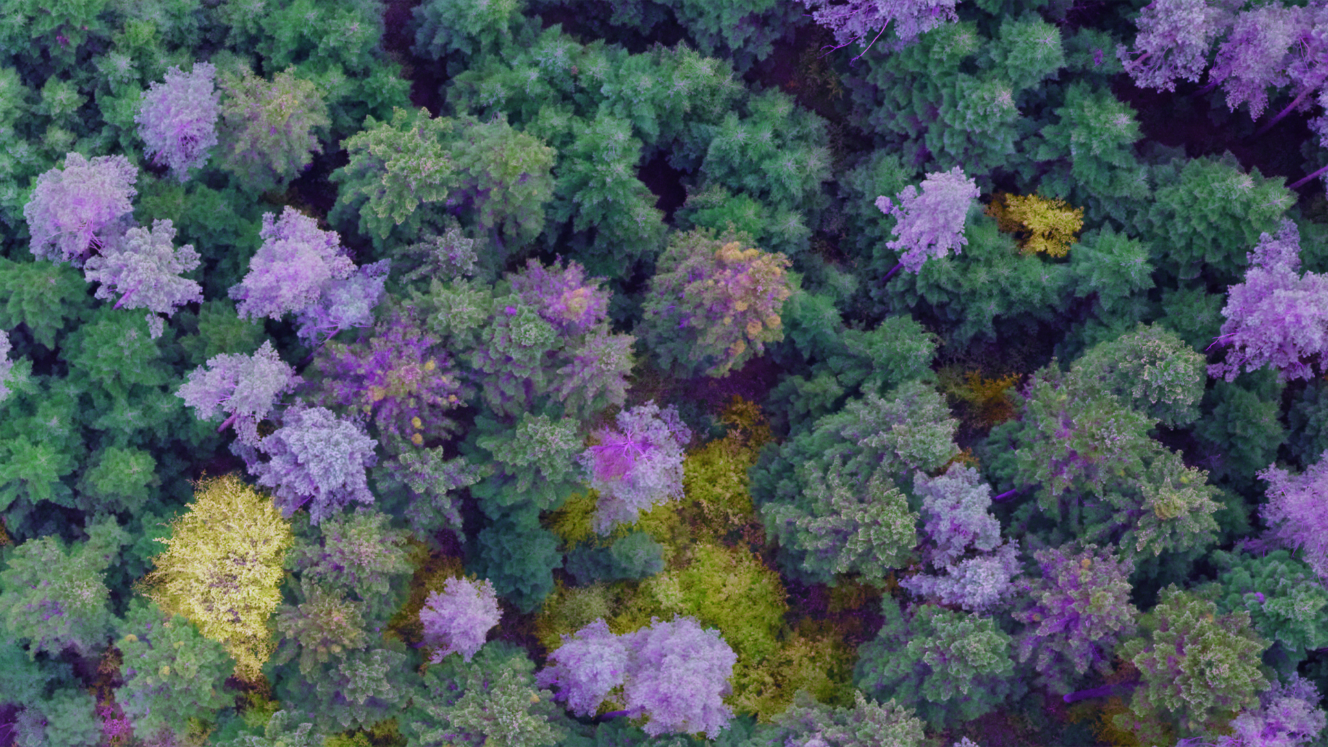
The high-resolution images effectively depicted the health condition of the trees down to the state of individual branches. This allowed AlterGeo to identify which trees were infested with parasites and assess the stage of their decline. Additionally, a special imaging technique enabled a significant differentiation of trees based on their health condition. The mapping technique also facilitates the recognition of tree species and sizes.
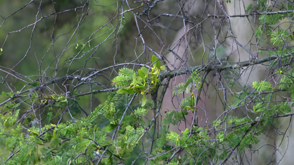
Fig.1. A young fir mistletoe (Viscum album) on a tree branch.
Measuring equipment
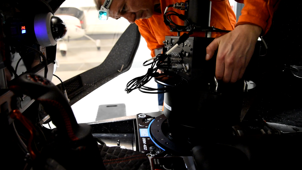
“The PAS 280 photogrammetry system mounted on a Somag DSM-400 seamlessly integrates with the Alter-Eye aircraft’s mounting holes. The equipment is housed inside the cabin, with the aircraft’s design fully accommodating the requirements of the Somag DSM-400 mount. Pre-installed power supply, communications, and structured cabling for GNSS antennas and displays ensured that the PAS 280 fits perfectly into the existing aircraft infrastructure. This seamless integration was crucial for us, allowing for a fast and easy installation,” said Antoni Labaj.
Fig.2. Phase One PAS 280 mounted in the Alter-Eye’s cabin.
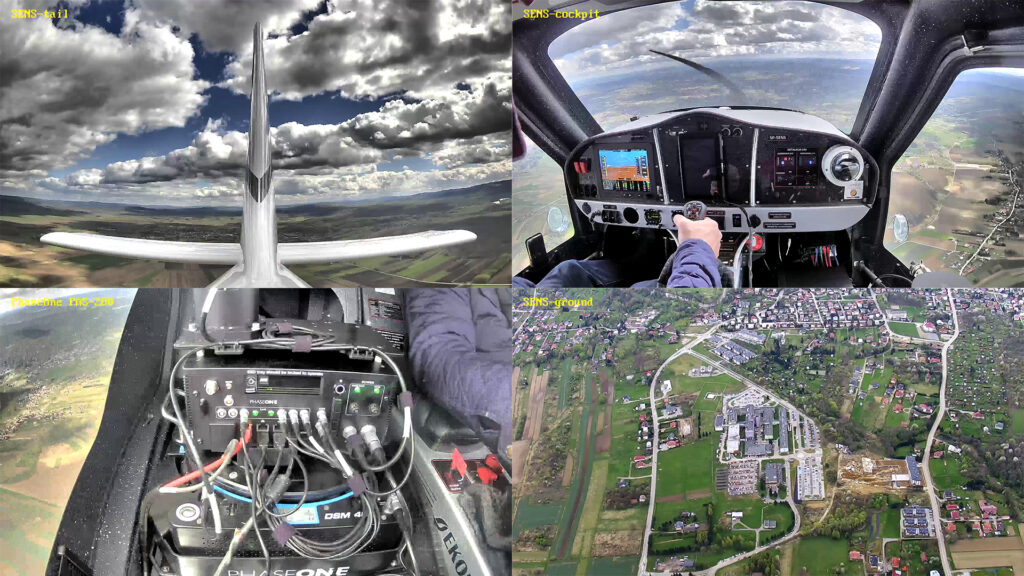
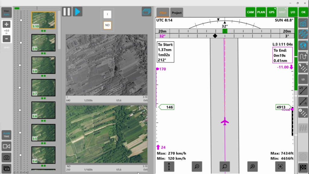
Data acquisition was managed via a high-speed remote connection, enabling comprehensive control of all on-board application parameters and video monitoring of flights. Although such extensive monitoring is not typically necessary during regular operations, it proves invaluable for testing and supporting the on-board pilot when new devices are used. Real-time communication with the pilot ensures seamless synchronization between the ground control station’s supervisory operator and the pilot in the aircraft cabin, enhancing the efficiency and accuracy of data acquisition.
Fig.3. Visual monitoring during Alter-Eye test flights.
In the office, multiple observers could analyze the flights, providing an excellent opportunity to demonstrate the system to individuals who cannot be on board the aircraft. This remote observation capability allows them to witness the device’s operation first-hand. If an acquisition error occurs, the operator can immediately instruct the pilot on how to rectify the issue before concluding the flight mission.
Fig.4. Phase One iX Flight application controlled remotely during data acquisition.
Acquisition technique
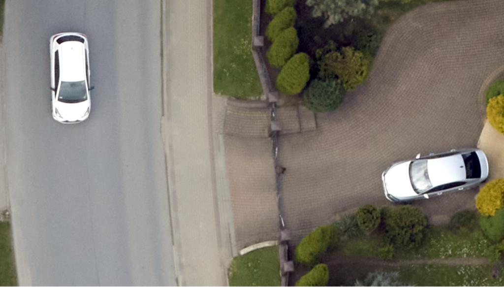
Data acquisition at a fixed resolution of GSD = 2 cm was achieved at a rate of approximately 40 km² per hour of flight. Flights were conducted under various weather conditions including full cloud cover and sunny skies. In both scenarios, the cameras successfully adjusted the exposure parameters, resulting in clear images. No motion blur was observed, even on moving vehicles.
Fig.5. Collected data quality example at GSD 2 cm during cloudy weather. No motion blur was recorded on a moving car below tree branches.
To minimize our carbon footprint, we utilize a small, fuel-efficient plane. The Alter-Eye aircraft emits just 29 kg of carbon dioxide per hour, offering a remarkable reduction in carbon footprint compared to traditional models, which emit around 250 kg per hour. By contrast, a typical car has a carbon footprint of 15 kg/h at 100 km/h. Phase One supplies the compact camera systems necessary for this, as they are the only provider capable of delivering such small, efficient systems.
Identifying tree diseases and dead wood
The exceptionally high resolution of the photos enabled clear visual identification of infected and dead trees without the need for additional inference techniques. Carefully chosen processing methods highlighted the differences between plant species and the living and non-living parts of trees. This level of processing makes it straightforward for anyone to identify diseased and dead trees. Decision-makers can then assess the extent of the damage first-hand and make informed decisions in line with the current forest management policies and climate initiatives.
The proposed technique has the potential to become a standard practice in forestry, superseding the laborious methods of collecting field data. These traditional approaches, constrained by numerous technical, human, and organizational limitations, often fall short of providing sufficiently objective, accurate, and efficient results.
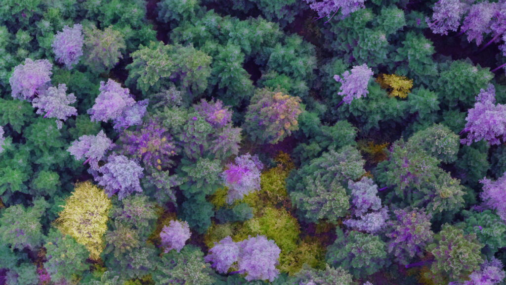
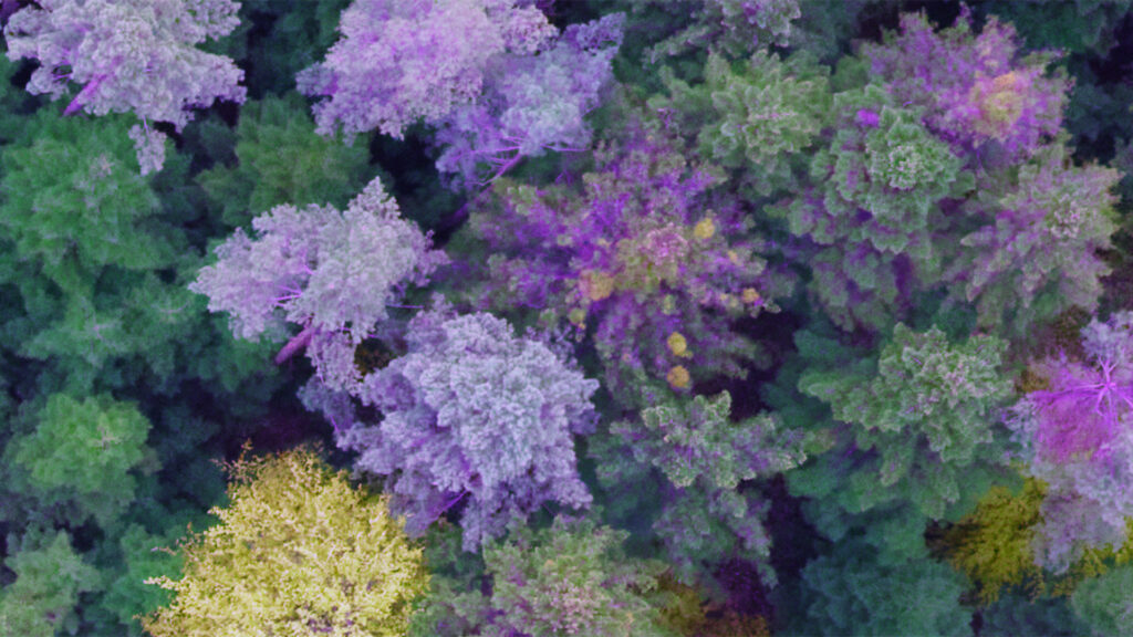
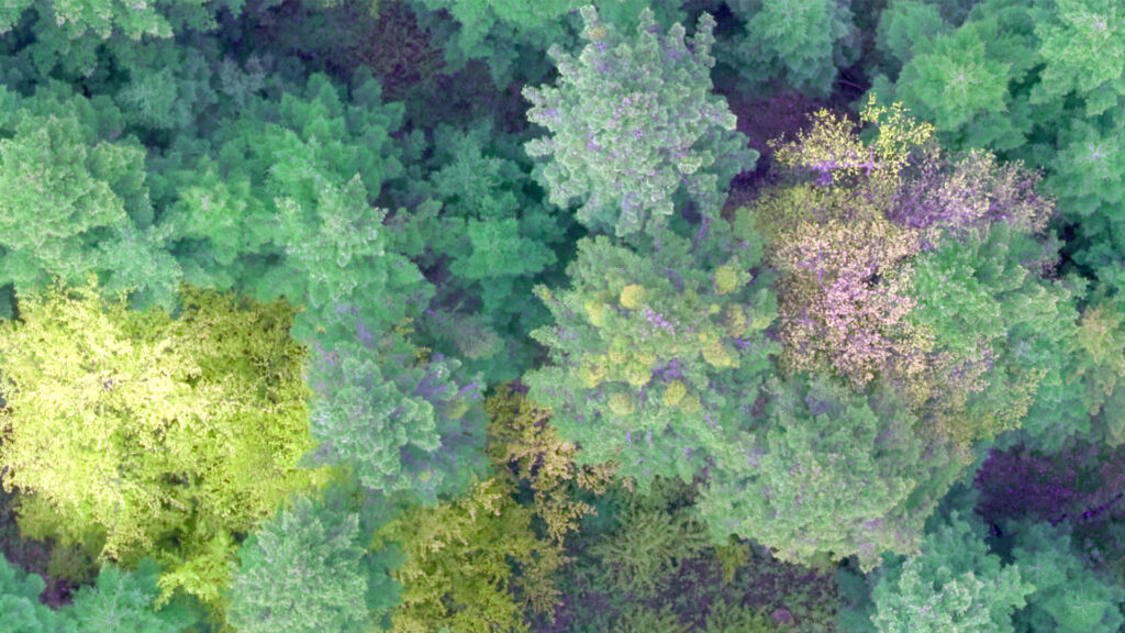
Fig.6. Processed photos for detecting tree diseases and dead wood.
Aviation-based techniques represent the inevitable future of environmental data collection, with the current capabilities already meeting the comprehensive needs of forest management. Compact systems such as the PAS 280 enable surveying companies to use a small aircraft for a smaller footprint, reducing the environmental impact of surveying projects. They also offer far more precise mapping and measurements compared to conventional field inventories, marking a significant advancement in forestry practices, and opening up potential applications in various other environmental fields.

Geospatial
Eight perspectives, one system

Geospatial
Finding tiny cracks with UAVs opens new opportunities

Geospatial
From capture to corridor intelligence: How Kavel 10 scaled 1 cm mapping with the Phase One + IGI CM-1

Geospatial
From sensors to solutions: How AISPECO orchestrates precision in reality surveying

Geospatial
Monitoring pipeline corridor using PAS 280 large format camera

Geospatial
Preventing Wild Bushfires By Mapping Planned Burns

Geospatial
Novice Aerial Photographer Becomes Advanced Mapping Provider

Geospatial
Inspecting Wind Turbine Blades While They Are Rotating

Geospatial
Precision at Altitude: Redefining Aerial Mapping with the PAS 880 Oblique Camera System

Geospatial
Perfecting telescope dish accuracy with UAV photogrammetry

Geospatial
Saving costs while lowering carbon footprint: Innovative aerial surveying service uses small airplanes enabled by compact cameras

Geospatial
Mapping lava flows during volcanic eruptions in Iceland

Geospatial
The PAS Pana: a 48,800-pixel camera innovated with our customer Surdex

Geospatial
Rebuilding after Hawaii’s wildfire with engineering-grade surveying

Geospatial
Revolutionizing Slovenian urban planning: Phase One’s PAS 880i redefines reality mapping