Preventing Wild Bushfires By Mapping Planned Burns
Aerial surveyors in Australia quickly ascertain the results of controlled fires using a large-format Phase One PAS 280i camera in challenging flying conditions – where time limits make effective data capture critical.
The Challenge
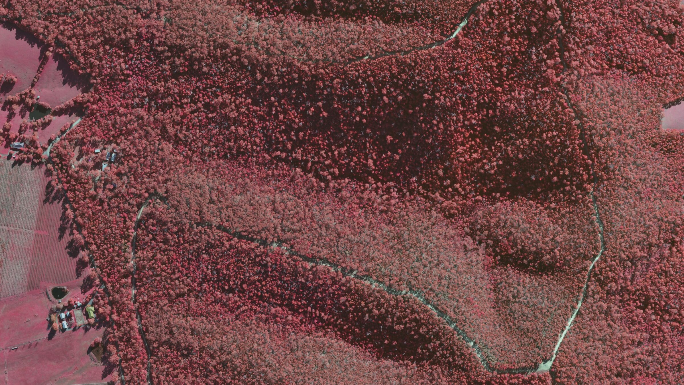
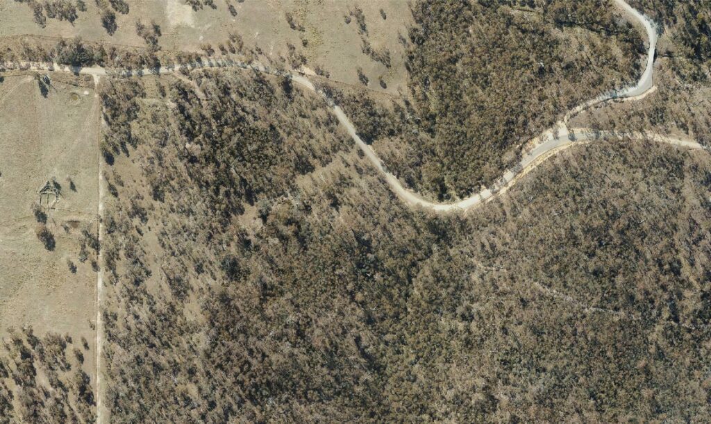
In the Australian state of Victoria, the Department of Energy, Environment and Climate Action lowers the risk of bushfires by reducing the amount of dry fuel across the landscape. To do this, their Forest Fire Management teams set controlled fires at specific sites in a program of planned burns.
After these individual fires, Landair Surveys needs to quickly establish the severity and extent of the burned area at each site. Flying over a wide area, they must perform localized mapping within an unyielding deadline, under challenging conditions.
A Brief Time Window
Once a controlled burn is finished and a ‘Ready to Fly’ notification is issued, Landair Surveys has just four weeks in which they can capture images and assess a site’s condition.
If they miss the small weather window, they need to attempt to gather data again later, unless the capture period has expired.
Erik Birzulis the CEO of Landair Surveys says, “If we are not able to capture a site, we do not get paid, and the client will have to rely on much lower-resolution satellite data for their mapping.”
Restrictive Flying Conditions
The burn season in Victoria coincides with challenging weather in late Autumn. Moreover, the planned fires often take place in mountainous areas. The resulting flying conditions make image capture difficult and limit the time available for flying.
Yet not only do Landair Surveys have a tight deadline. They must cover numerous separate sites and fly over a large area. In 2024, there were thirty sites scattered across the state of Victoria, ranging in size from 3 km² to 140 km².
To guarantee usable, high-resolution images even in adverse conditions, Landair Surveys needs highly reliable equipment they can depend upon.
The Phase One Solution
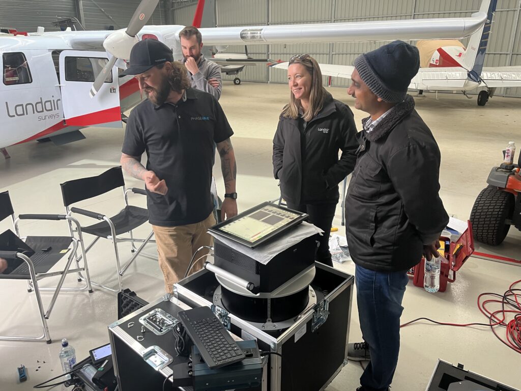
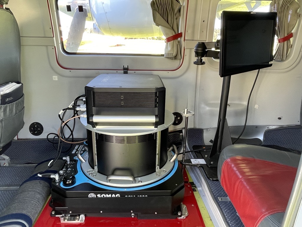
In May 2024, Landair Surveys upgraded to a Phase One PAS 280i 4-band airborne sensor system.
This large-format camera system is installed in a pod assembly on a Vulcanair P.68C – a twin-engine aircraft designed for demanding conditions and versatile operations.
Previously, Landair Surveys used a medium-format camera system, but its smaller footprint meant they needed more time in the air to capture the required imagery. This cost time and meant they missed opportunities to complete the overall image capture within the small weather window.
“The large format Phase One camera system saves us around 40% capture time compared to our previous medium-format camera system, and it provides very sharp, high-quality imagery,” says Erik Birzulis.
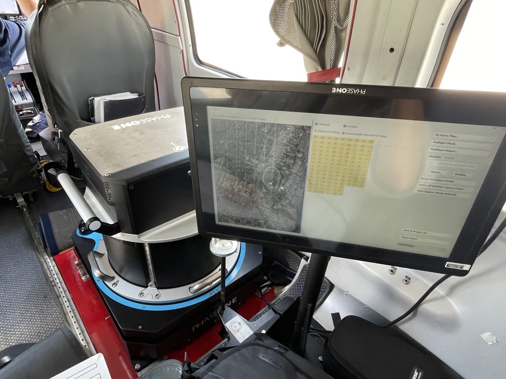
In addition to the PAS 280i solution, Landair Surveys also utilizes the full iX Suite software, covering project planning, flight management, data acquisition, review, and processing. The ability to view images during the flight mission and make real-time decisions while in the air has further optimized operational efficiency.
“With iX Suite, we can review images instantly and make adjustments on the fly, ensuring we get the best possible results in a single mission. This seamless workflow not only saves time but guarantees quality from the very first stage,” says Erik Birzulis.
The large format Phase One camera system saves us around 40% capture time compared to our previous medium-format camera system, and it provides very sharp, high-quality imagery.
Streamlined Processing with Correlator3D
In addition to utilizing the Phase One PAS 280i camera system, Landair Surveys also relies on SimActive’s Correlator3D photogrammetry software to process the high-resolution imagery captured during their aerial surveys. Correlator3D efficiently handles the large datasets produced by the Phase One system, including the 4-band imagery, by creating Digital Elevation Models and stitching the imagery into seamless orthomosaics. The software’s advanced algorithms ensure that the resulting outputs maintain high spatial accuracy, even without ground control points.
According to Dr Philippe Simard, CEO of SimActive, “Correlator3D was specifically designed to work with large-format imagery such as Phase One Geospatial cameras. Its powerful algorithms allow Landair Surveys to quickly turn large volumes of aerial data into reliable results, enabling them to meet their tight project deadlines and deliver critical mapping products.”
Spatial Imaging Requirements
To assess the burn sites, which are mostly in forested areas, Landair Surveys needs a GSD of 15 cm to 20 cm or better, four-band RGBI aerial photography, and the production of relaxed accuracy, ortho-rectified true- and false-color imagery products.
With no ground control points, Landair Surveys needs a good spatially accurate solution using their on-board Applanix GNSS and IMU, which is post-processed using POSPac MMS.
Success with the Phase One PAS 280i
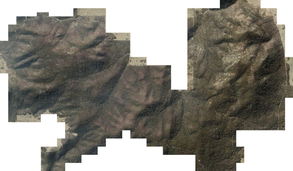
Mapping the 2024 hazard reduction burn project, Landair Surveys successfully covered an area of 570 km², with their Phase One camera ensuring efficient, precise, and reliable data capture. The resulting imagery has been used by the government department to map the extent and severity of the fires at the planned burn sites.
“The PAS 280i is high-quality and exceeds expectations,” says Erik Birzulis. “We are very happy with the spatial accuracy achieved, usually exceeding +/- 2 x GSD RMSE.”
Using the new system, Landair Surveys’ largest projects to date have been covered 31 towns in an area of 2,394 km² in North Queensland, and 87 towns in an area of 1,360km² in Victoria.
More about Landair Surveys
Landair Surveys is an Australian company providing land and aerial surveying services for corporate and government clients in the infrastructure, environment, property, and resources industries.
Their aerial survey department mainly performs large aerial photography projects for the state governments of Queensland, New South Wales (NSW), Victoria, and Tasmania.
The company provides traditional 3D photogrammetric vector mapping for small project sites, bushfire and hazard-reduction burn mapping, township, city and large rural area mosaics, and 3D photogrammetric mapping from historical imagery.
You can read more on the Landair Surveys website.

Geospatial
Eight perspectives, one system

Geospatial
Finding tiny cracks with UAVs opens new opportunities

Geospatial
From capture to corridor intelligence: How Kavel 10 scaled 1 cm mapping with the Phase One + IGI CM-1

Geospatial
From sensors to solutions: How AISPECO orchestrates precision in reality surveying

Geospatial
Monitoring pipeline corridor using PAS 280 large format camera

Geospatial
Novice Aerial Photographer Becomes Advanced Mapping Provider

Geospatial
Inspecting Wind Turbine Blades While They Are Rotating

Geospatial
Precision at Altitude: Redefining Aerial Mapping with the PAS 880 Oblique Camera System

Geospatial
Perfecting telescope dish accuracy with UAV photogrammetry

Geospatial
Saving costs while lowering carbon footprint: Innovative aerial surveying service uses small airplanes enabled by compact cameras

Geospatial
Detecting forest tree diseases using a large-format camera on an ultralight aircraft

Geospatial
Mapping lava flows during volcanic eruptions in Iceland

Geospatial
The PAS Pana: a 48,800-pixel camera innovated with our customer Surdex

Geospatial
Rebuilding after Hawaii’s wildfire with engineering-grade surveying

Geospatial
Revolutionizing Slovenian urban planning: Phase One’s PAS 880i redefines reality mapping