Rapid aerial photogrammetry with high-precision GNSS geo-referencing enables experts to precisely monitor eruptions even under extreme conditions, helping to keep people safe.
Mapping lava flows during volcanic eruptions in Iceland
The challenge
For a country that is a hotbed of volcanic and seismic activity, geoscientists in Iceland need to be constantly aware of volcanic unrest and react quickly to new developments by mapping new environmental changes and lava flows. This is one of the roles of the Icelandic Institute of Natural History (IINH) which runs a photogrammetry lab in collaboration with leading institutes in geohazards in Iceland.
Speed and safety are critical, which results in the photogrammetry team to prefer a small airplane over drones to minimize people on the ground.
Facing extreme conditions from volcanic plumes and adverse weather, their flight plans need to be flexible enough to work with what is possible in the air at each moment.
Once safely back on the ground, the data then needs to be processed quickly and sent onwards for use by other agencies and actors, including for the Civil Protection.
The photogrammetry lab of the IINH:
- Creates 3D models for photo-geology
- Conducts surveys of active environments such as volcanoes, landslides and glaciers.
- Monitors geoheritage sites
- Monitors Surtsey island
- Data is open access
The eruptions nearby Grindavík town
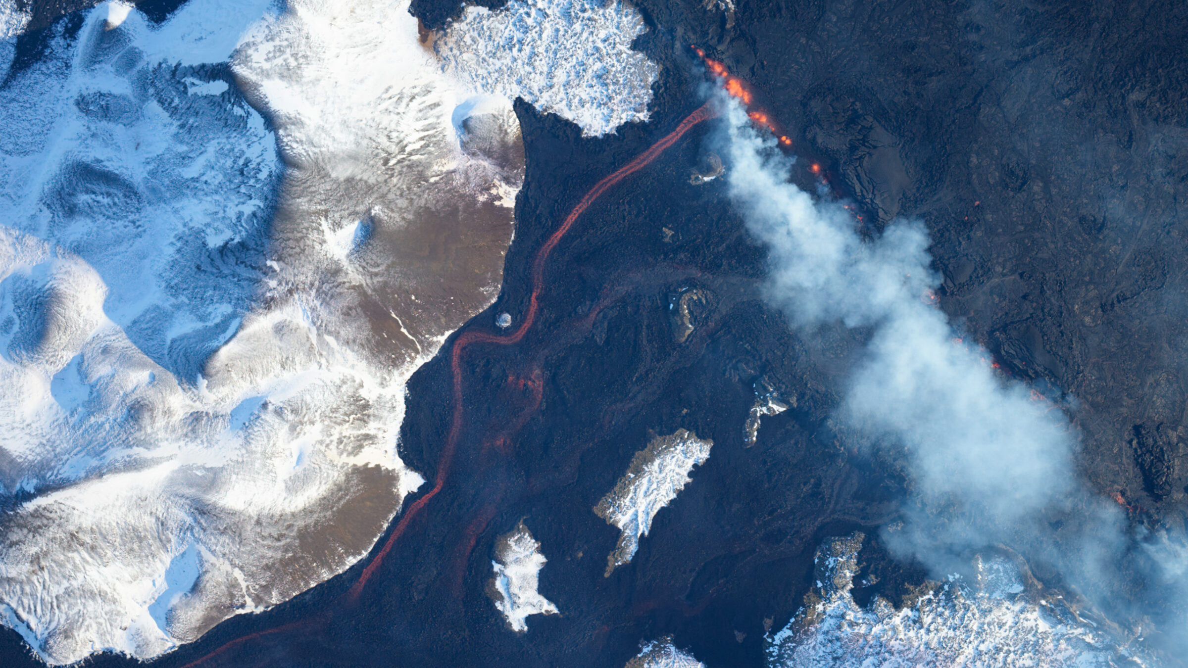
December 2023 saw a change in volcanic activity, when a dramatic new fissure eruption began just north of the town of Grindavík, situated on the Reykjanes peninsula southwest of Reykjavík. This latest activity on the peninsula was preceded by three other eruptions in Fagradalsfjall, another volcano nearby, that started in 2021. Since then, the inhabitants of Grindavík, have had to battle the forces of nature in ways no one wants to experience, with numerous earthquakes and eventually lava flows that reached the town. Mapping these lava flows is a task done by the photogrammetry lab of the IINH, directed by Birgir V. Óskarsson.
“The area is very active now – since 2021 we have had seven eruptions,” says Birgir. “We have had tectonic activity as precursors and then a series of eruptions as the ones above Grindavík.”
During the volcanic unrest, the town subsided by more than one meter with the activation of faults, with nearly 4,000 people displaced, and a lot of damage to houses and buildings from fire and subsidence. However, the people of Iceland are determined to fight against the forces of nature. After initially evacuating, they are keen to protect their homes and businesses, but it is hard to predict when it will be safely possible to return.
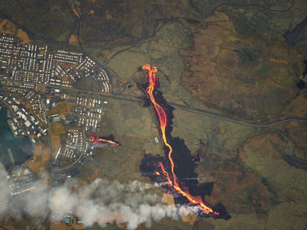
Lava erupting above the town Grindavík on January 24th 2024. The lava was diverted away from the town by a barrier built shortly before the eruption.
Photogrammetry reveals trends and hidden dangers
High-resolution nadir imagery is essential for monitoring the hazards and allows the photogrammetry team to generate Digital Elevation Models (DEM), orthoimages, and 3D mesh models – all to follow the progress and evolution of the lava field. By accurately mapping the flow and measuring the area and volume of the lava flows, the authorities can better mitigate the hazards and predict the course of the flows. They compare DEMs of the lavas at different times to calculate the volumes erupted and estimate the lava effusion rate, i.e. how much lava is discharged at a given time. From comparisons between surveys, the team can also gain insights into changes in the lava fields and to better see what is happening below the crust of the lava flows, which can for example inflate if the flows is obstructed. “It is usually hard to see,” says Birgir. “But with these DEMs we can see areas that are inflating and become dangerous because they can suddenly breakout – causing a sudden surge of lava – and if there are a lot of people around, that
could mean fatalities.”
Lava eruption through one of the barriers built to protect the town of Grindavík on January 24th 2024.
Specifying a new aerial system
As the photogrammetry lab of the IINH provides data used by the civil protection and others working with hazard assessment, their operations need to be extremely efficient at image collection and photogrammetric processing. Previously, the IINH has used standalone cameras for volcano monitoring, and manually worked with the data. But without a proper aerial system the processing was tedious.
Birgir explains: “It was crucial for us to acquire a full aerial system with the camera placed in a stabilizer, with a controller, flight management system, high-precision GNSS and Inertial Measurement Unit (IMU): One proper system that plans the flight lines, with the correct number of images and overlap. That spares you a lot of time planning and processing the data.”
The IINH photogrammetry team uses airplanes with medium-format cameras because they can cover larger areas in a much shorter time than drones. Airplanes can also fly high, usually safely above the air traffic such as drones, helicopters, and smaller planes. Moreover, drones need to be deployed from the ground, which is not always feasible in volcanic situations where drone operators would need to be located near dangerous hazards.
“Our motto is light and fast; we have built our surveys around lightweight, medium-format cameras, meaning we can quickly install the system in the aircraft during an emergency and move towards the targeted area,” says Birgir.
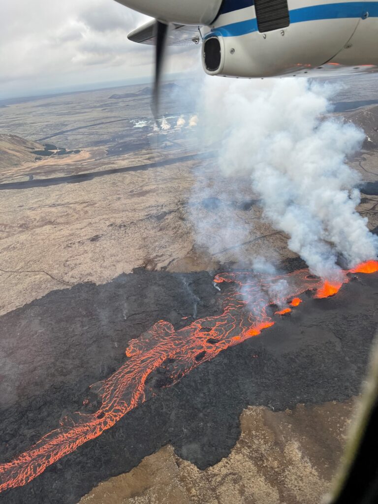
The crater row of Sundhnjúksgígar eruption seen from the window of the aircraft on March 20th 2024.
Difficult conditions require flexibility to get results
When dealing with volcanic eruptions, flight plans with overlapping corridor patterns do not always stand up to the real-world challenges of volcanic plumes and associated turbulence. The surveys can often fly each line only when it becomes possible, and often lines need to be improvised.
When possible, the surveys aim for high flight as they can cover the area with only a few images. But very often the Icelandic weather only allows for low flights, with many cloudy and windy days limiting their altitude. Consequently, taking oblique imagery is also part of the teams’ toolkit.
Having all images geo-referenced with precise coordinates is a powerful advantage for the photogrammetry team because it significantly reduces the need for people to be on the ground placing numerous physical control points around the lava flow. Ground control points are also frequently overrun by the lava and destroyed, requiring the team to replace them.
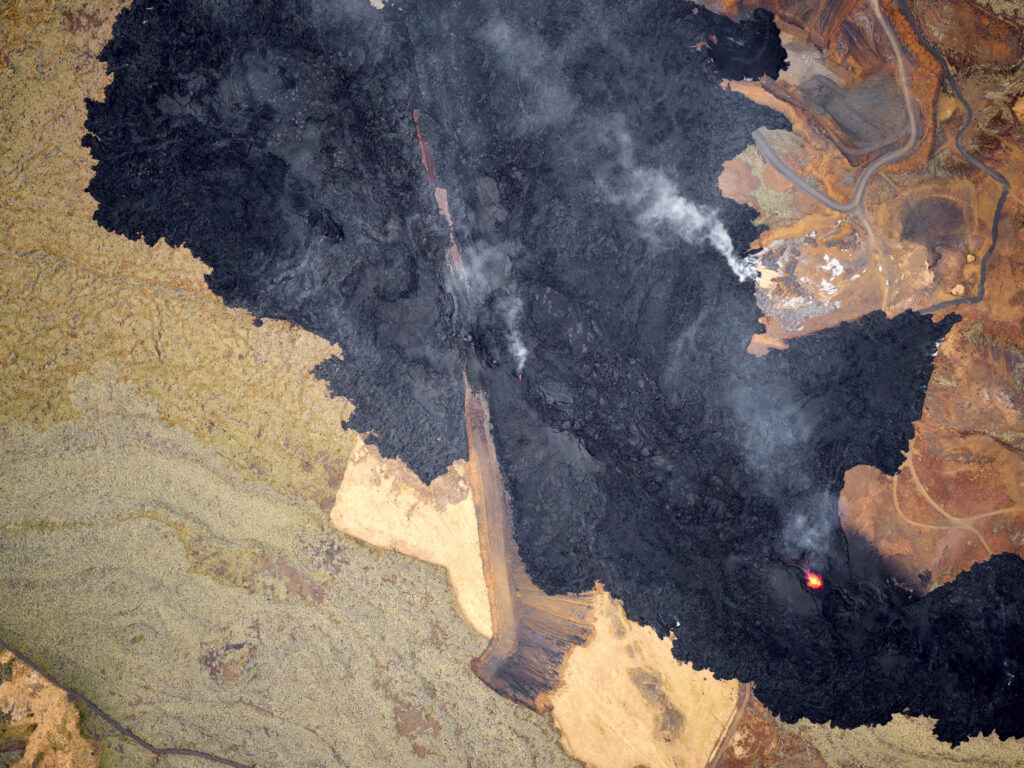
Image showing the size of the lava field of Sundhnjúksgígar on April 8th 2024.
The Phase One solution
To meet the needs of the photogrammetry team, Phase One specified a PAS system. It comprises an iXM 100MP camera mounted in a small system frame, which is then mounted in a small SOMAG stabilizer. The camera is controlled by the iX MK5 controller with integrated Applanix GNSS and inertial system. The Phase One software iX Flight Pro is also an essential element, making an aerial imaging system that is highly efficient and enables the team to cover an area in just a few minutes.
We chose Phase One because it is just on another level, Phase One is leading the market when it comes to aerial systems for medium-format cameras. We considered other suppliers, and some had most of the components, but none had all of them integrated nicely into one aerial system. We are extremely excited about the results so far from our surveys. We have flown in all kinds of conditions, even around the solstice, when the angle of the sun is two degrees in Iceland. Companies do not usually offer surveys when the sun is below 10 degrees, due to the challenges of such conditions. It was quite cloudy too, but we still managed to get the data we needed.
Easy planning saves time and adapts to changes
The flight planning software iX Plan has brought considerable benefits to the operations.
“It is a game changer to be able to plan your flight to the extent the software helps you plan and then fly it. It is so much easier for everybody: for the pilot, and for us controlling the equipment to run the operation. It saves us a lot of stress and time,” Birgir says.
The iX Plan software also helps adapt their flight plans to the volatile reality in the skies around volcanoes. It enables the team to obtain the correct image overlap despite these conditions, considerably reducing their processing time later.
“Because of the challenges with following the flight lines, I may need to do some improvisation, but the iX Flight Pro software allows for that. I can select a line that I want to fly by eyesight and then run the interval image capture. So I can do both: I can follow the lines and then improvise with other lines that I just make on the spot,” Birgir explains.
The iX Process software helps Birgir save time by giving an overview of the captured images that enables him to quickly select the images that he wants to process and piece together.
The Phase One solution enables the team to quickly deliver their results onwards to the many other agencies such as civil protection or companies planning rebuilding work who need to assess the dangers. The photogrammetry team send data to the civil protection within hours after a survey. The system helps to reduce processing time, since it automates the image capture and the stabilization compensates for the movements of the plane, ensuring images are all properly nadir and with good overlap.
The coordinators of the photogrammetric surveys, Joaquín Belart from the National Land Survey of Iceland (left) and Birgir V. Óskarsson from the Icelandic Institute of Natural History (right).
Simplicity empowers more users
Making the surveying process easier has reduced the workload significantly.
Establishing a simplified process will also make it easier for other people to operate the system, such as when a long-lived eruption necessitates a larger team to rotate shifts.
“It is very easy to plan low or high flights,” says Birgir. “With Phase One’s system being user-friendly, we can train more people to run the operations.”
Ready for future projects
While the PAS system has become an essential tool for monitoring volcanic eruptions in Iceland, the photogrammetry team also plans to use it for landslide monitoring, glacial monitoring, glacial flood surveillance, monitoring the uninhabited volcanic island of Surtsey, and more.
“There are many other places up on the highlands and in glaciers that are very difficult to access, where it is almost impossible for us to place control points. So having this system with high-precision GNSS geo-referencing will save us a lot of headaches and work,” Birgir says.
The photogrammetry team is now planning a project to investigate surface changes in glaciers caused by geothermal anomalies that act as potential precursors of subglacial volcanic activity, which can produce meltwater in vast quantities and cause dangerous floods.
“We have had floods in the past the size of Amazon River, with 200,000 cubic meters per second of flow when volcanoes erupt under glaciers,” says Birgir. “These cause severe threat to the impact areas and therefore need to be monitored effectively.”
Geospatial
Monitoring pipeline corridor using PAS 280 large format camera
Geospatial
Preventing Wild Bushfires By Mapping Planned Burns

Geospatial
Novice Aerial Photographer Becomes Advanced Mapping Provider

Geospatial
Inspecting Wind Turbine Blades While They Are Rotating

Geospatial
Precision at Altitude: Redefining Aerial Mapping with the PAS 880 Oblique Camera System

Geospatial
Perfecting telescope dish accuracy with UAV photogrammetry

Geospatial
Saving costs while lowering carbon footprint: Innovative aerial surveying service uses small airplanes enabled by compact cameras

Geospatial
Detecting forest tree diseases using a large-format camera on an ultralight aircraft

Geospatial
The PAS Pana: a 48,800-pixel camera innovated with our customer Surdex

Geospatial
Rebuilding after Hawaii’s wildfire with engineering-grade surveying

Geospatial
Revolutionizing Slovenian urban planning: Phase One’s PAS 880i redefines reality mapping
Geospatial
Imaging solutions combined with AI and 5G – A new approach and promising to assess forest health and detect and monitor wildfires
Geospatial
Phase One Cameras combined with light, fixed-wing aircraft deliver highly efficient LiDAR and mapping missions
Geospatial
Capturing Glastonbury Festival
Geospatial
Breaking barriers to offshore wind energy development