Aerial Image Capture using Phase One Technology
Capturing Glastonbury Festival
Producing an aerial imagery orthophoto
Producing an aerial imagery orthophoto of the 2023 Glastonbury Festival relied on provision of cost effective and environmentally friendly aircraft and camera solution to deliver a photogrammetric solution that successfully navigated aerial imaging options.
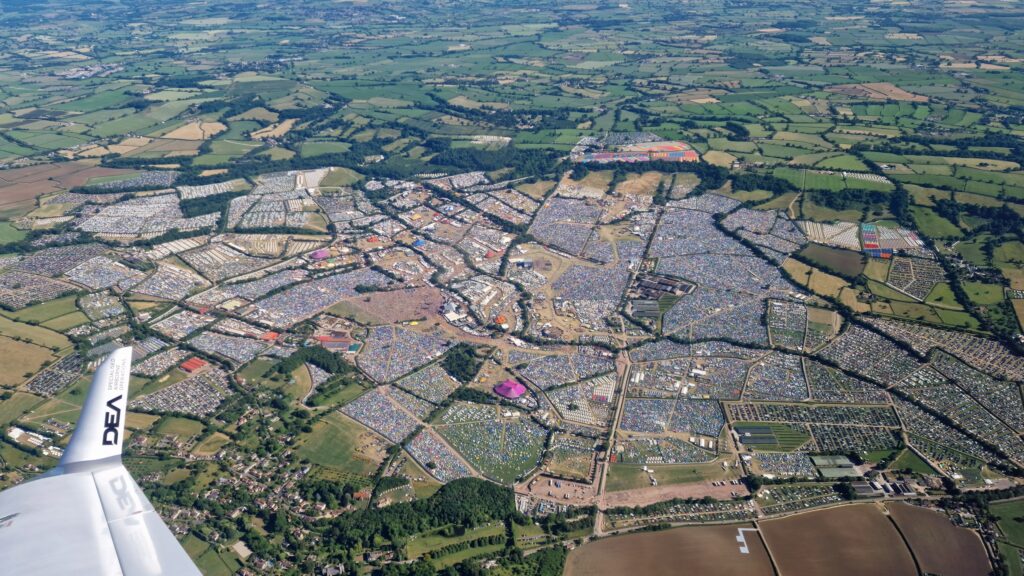
Glastonbury Festival is the largest greenfield music and performing arts festival in the world, famous for its multiple days of music, poetry, and artistic performances. It famously began the day after Jimi Hendrix died in 1970 and has celebrated musical diversity nearly every year since.
Aerial imagery for festival planning
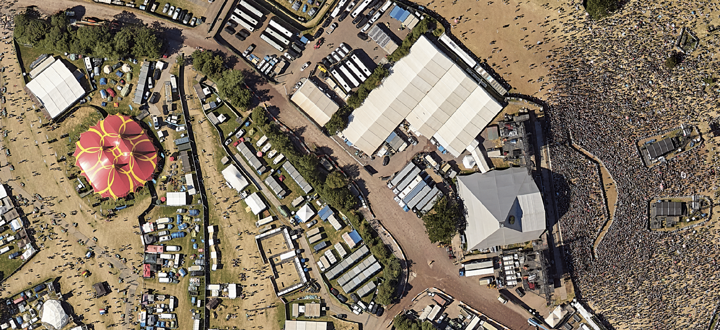
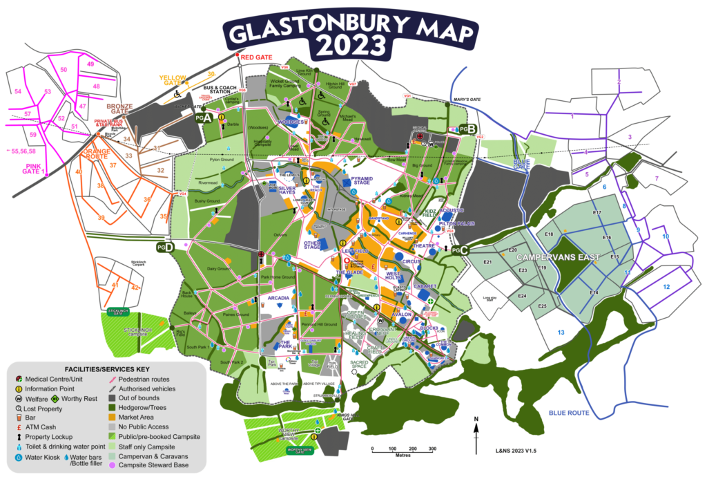
Photographing this iconic event is a key priority for event organizers where more than 200,000 people gather to enjoy music across multiple stages at Worthy Farm in Somerset. Capturing aerial imagery is important for the organizers, as these images are used to review the staging positioning, and to plan future festivals across the vast, iconic area where Glastonbury is hosted each year.
From an aerial perspective, there was one major challenge. The project was outside of the scope of camera-mounted drone capture due to UAV safety restrictions and limitations, a heavier aircraft carrying large format camera (LFC) systems would have been prohibitively expensive and environmentally unfriendly. What was needed was a cost-effective, safe, and low carbon emission aircraft camera solution.
Phase One imaging technology offers flexibility and easy installation
DEA Aviation, a world leading technology-led provider of specialized aerial data acquisition services had its high-efficiency Diamond DA–42 aircraft fitted with a Phase One PAS 150 compact aerial camera system with an RS-50mm lens. The DEA experts chose Phase One imaging technology because it was the perfect solution. The system could both capture and efficiently process the requisite high quality aerial images and offer superior flexibility and ease of installation.
The entire PAS 150 kit has such flawless integration between its multiple pieces, and as a result, provides a full and effective package to easily perform what would otherwise be complicated tasks.


Capturing High-Quality Images at 3,250ft AMSL
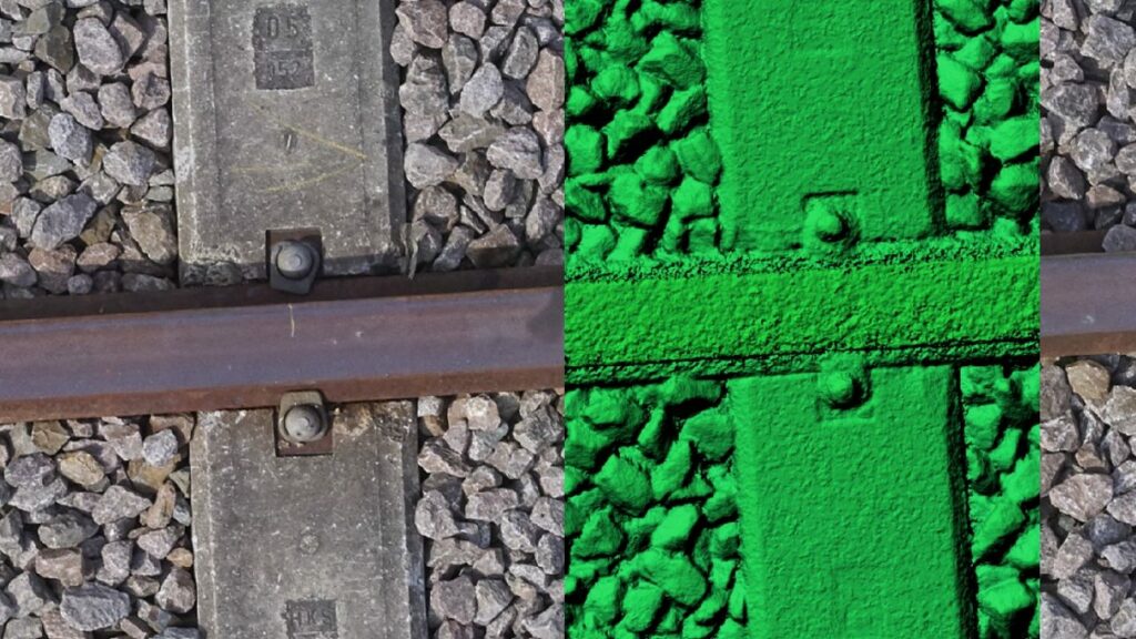
Flying at an altitude of 3,250ft Above Main Sea Level (AMSL) due to a local Notice to Airmen (NOTAM) restriction of 3000ft AMSL, this resulted in a Ground Sample Distance (GSD) of 6.5 cm. GSD is a metric used in aerial surveillance that determines the quality of the photograph, effectively the distance on the ground that would be visible to the observer.
From start to finish, it took just one hour of image capture, covering a total area of approximately ~30KM2 spread across the main festival site, and three smaller logistical targets. With a total system weight of 19kg this was easily captured in a single flight of the DA42 including transit to and from DEA’s base at Retford Gamston Airport.
Processing the dataset
A total of 246 images were captured with a 60% forward and 30% side overlap used. The whole dataset was processed and delivered in one week, due to the efficiency of the iX Process, Phase One’s proprietary processing solution. With the iX Process it was possible to radiometrically, and geometrically correct all captured raw files, and export to Tiff files in less than two hours, meaning that data was quickly ingested into the AT and further downstream processing workflow extremely efficiently.
Paul Evans, the Senior Business Manager for DEA described the process:
“With great support from Phase One we completed a very successful flight over one of the world’s iconic events. The camera technology of the PAS 150 system delivered high quality imagery and because the PAS 150 system is robust, compact and lightweight we could fly using our fuel efficient and low carbon emission Diamond DA-42 aircraft.”
About DEA
DEA Aviation Limited (DEA) is a world leading technology-led provider of specialized aerial data acquisition services. DEA deploys state-of-the-art aerial sensing and digital processing technology in dynamic, challenging environments worldwide and is frequently relied upon to provide critical security services of national importance, demanding class-leading safety, and compliance processes.
DEA’s Innovative Technology is industry leading, and our expertise, experience and capability form the foundation of everything we do.
About Glastonbury Festival
Glastonbury Festival is a five-day festival of contemporary performing arts held near Pilton, Somerset, England in most summers. In addition to contemporary music, the festival hosts dance, comedy, theatre, circus, cabaret, and other arts. The event has run for over 50 years commencing in 1970 on the Eavis family farm.

Geospatial
Eight perspectives, one system

Geospatial
Finding tiny cracks with UAVs opens new opportunities

Geospatial
From capture to corridor intelligence: How Kavel 10 scaled 1 cm mapping with the Phase One + IGI CM-1

Geospatial
From sensors to solutions: How AISPECO orchestrates precision in reality surveying

Geospatial
Monitoring pipeline corridor using PAS 280 large format camera

Geospatial
Preventing Wild Bushfires By Mapping Planned Burns

Geospatial
Novice Aerial Photographer Becomes Advanced Mapping Provider

Geospatial
Inspecting Wind Turbine Blades While They Are Rotating

Geospatial
Precision at Altitude: Redefining Aerial Mapping with the PAS 880 Oblique Camera System

Geospatial
Perfecting telescope dish accuracy with UAV photogrammetry

Geospatial
Saving costs while lowering carbon footprint: Innovative aerial surveying service uses small airplanes enabled by compact cameras

Geospatial
Detecting forest tree diseases using a large-format camera on an ultralight aircraft

Geospatial
Mapping lava flows during volcanic eruptions in Iceland

Geospatial
The PAS Pana: a 48,800-pixel camera innovated with our customer Surdex

Geospatial
Rebuilding after Hawaii’s wildfire with engineering-grade surveying