From capture to corridor intelligence: How Kavel 10 scaled 1 cm mapping with the Phase One + IGI CM-1
Customer Snapshot
Who: Kavel 10
Challenge: Deliver 1 cm corridor imagery from a fixed-wing aircraft—at operational speed and safe altitude—without motion blur, workflow friction, or unmanageable data volumes.
Solution: IGI CM-1 system, integrating Phase One iXM-FS130 camera with IGI Direct Trajectory, 4 images per second trigger rate, stabilization, and curved corridor flight planning.
Result: High-detail, repeatable corridor capture that supports inspection-grade analysis and AI-ready workflows—while remaining efficient in both flight and processing.
Raising the bar for aerial corridor mapping
As reality capture, digital twins, and infrastructure monitoring mature, aerial survey operators are under pressure to deliver higher resolution data more frequently, without increasing operational complexity or cost.
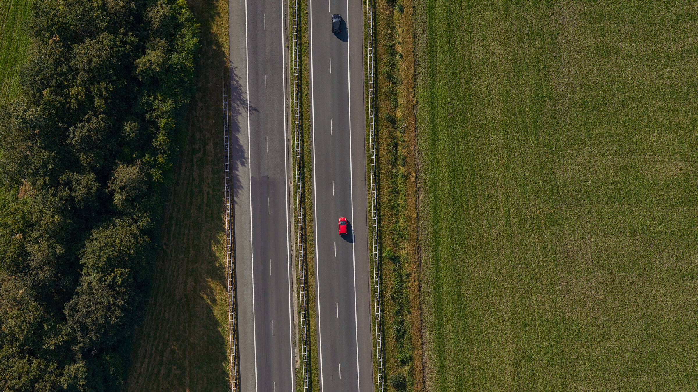
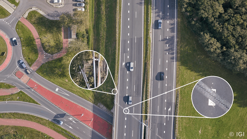
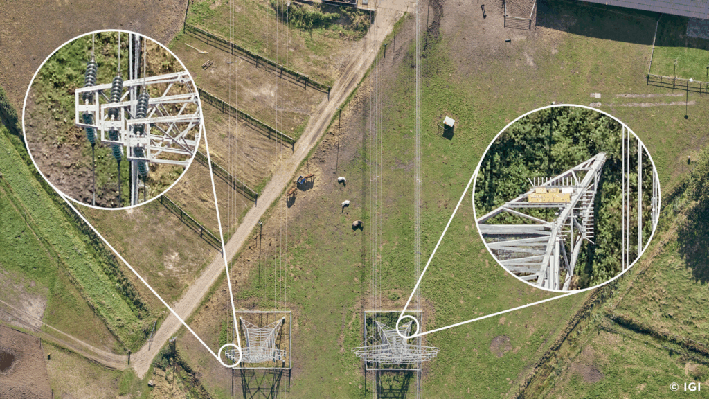
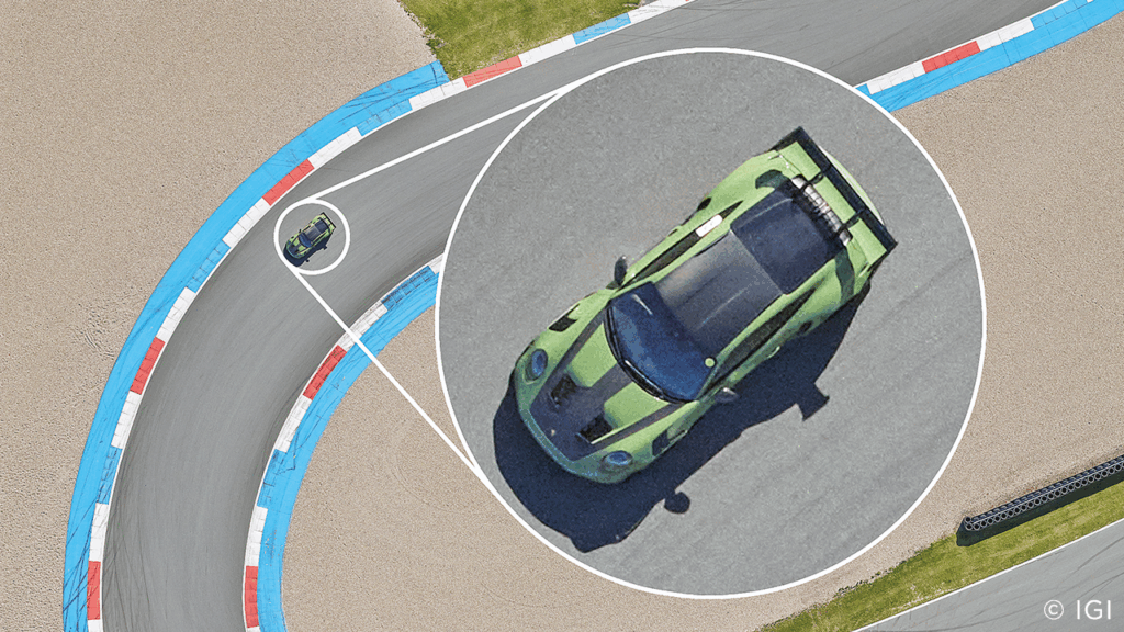
For Kavel 10, a European aerial survey operator running large-scale programs across the Netherlands and beyond, this shift meant moving beyond conventional 5 cm products toward 1 cm ground sampling distance—a resolution level that unlocks inspection-grade insight and supports automated analytics.
“We focus on delivering the best image; that is our brand promise—the best image,” explains Sam van Kerkhof, Project Manager, Kavel 10.“ At higher resolution, the amount of usable information increases dramatically.”
The fixed-wing challenge at 1 cm
While drones and helicopters can achieve ultra-high resolution at low speed and altitude, fixed-wing aircraft introduce unique constraints. Minimum airspeed, motion blur, camera cycle time, and overlap reliability all become critical factors—especially for corridor mapping, where curved trajectories and long linear assets demand both precision and efficiency.
At 1 cm GSD, these constraints can quickly erode image quality or force inefficient flight profiles. Kavel 10 needed a solution that could maintain clarity, consistency, and throughput under real operational conditions.
CM-1: system-level integration, not just a camera
The CM-1 addresses these challenges through the tight integration of Phase One imaging technology with IGI airborne systems, creating a purpose-built solution for high-resolution corridor capture.
Phase One imaging: detail without compromise
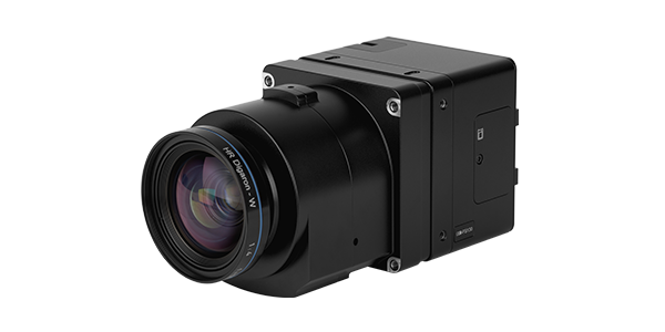
At the core of CM-1 is a Phase One iXM-FS130 camera, with high-resolution capture at operational flight speeds. High repetition rates allow dense coverage even at fixed-wing velocities, while global shutter capability minimizes motion blur capture at operational flight speeds.
To handle the resulting data volumes, Phase One introduced IIQ-X compression, reducing file sizes significantly compared to uncompressed 16-bit imagery, without sacrificing photogrammetric integrity. GPU-accelerated processing further shortens the path from landing to usable data.
“AI-driven applications require not just more data, but better data,” notes Robert Bosch, Product Manager at Phase One. “The more detail in the input, the better the output.”
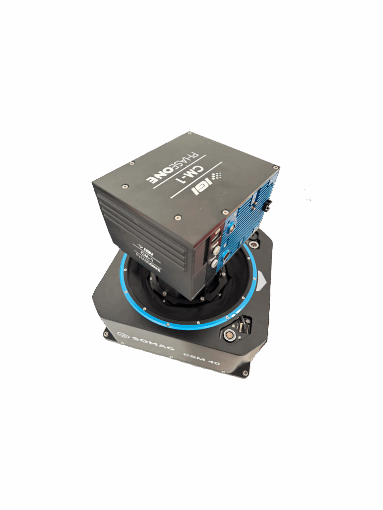
IGI airborne intelligence: keeping geometry intact
IGI’s contribution ensures that image quality translates into geometrically reliable datasets. Integrated GNSS/IMU, high-rate triggering, and stabilized mounting maintain consistency even during curved flight paths.
“At 1 cm resolution, image quality alone isn’t enough,” says Philip Grimm, CEO at IGI. “You need precise integration between navigation, triggering, flight planning and the image sensor. With CM-1, we engineered the system so that high-frequency capture becomes possible while maintaining image quality and geometric accuracy—even in curved corridor flights. And because CM-1 supports pilot-only missions, operators can stay in the office and focus on efficiency without ever compromising data quality.
Crucially for linear assets, corridor flight planning allows the aircraft to follow roads, railways, and infrastructure directly capturing only what matters, while preserving overlap and photogrammetric strength.
With CM-1, we have a fully operational system that proves what iXM-FS130 enables in practice. The combination of Fusion Shutter™ technology, high-speed image capture, and tight system integration allows operators to fly fast, maintain image integrity, and execute complex missions with confidence. This is not a concept — it is a production-ready solution.
Why 1 cm changes how data is used
For Kavel 10, the jump from 5 cm to 1 cm is not incremental—it is transformational.
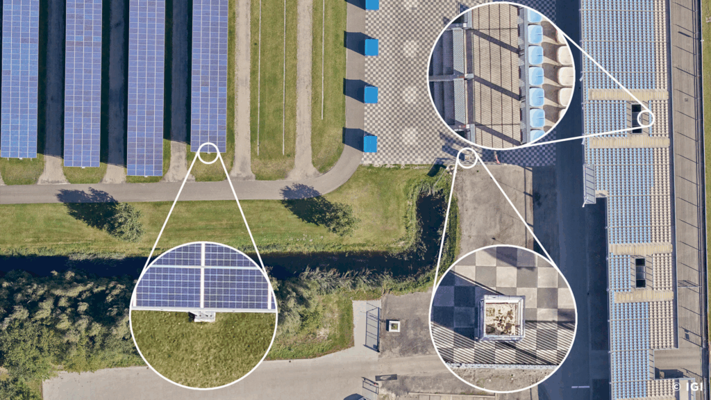
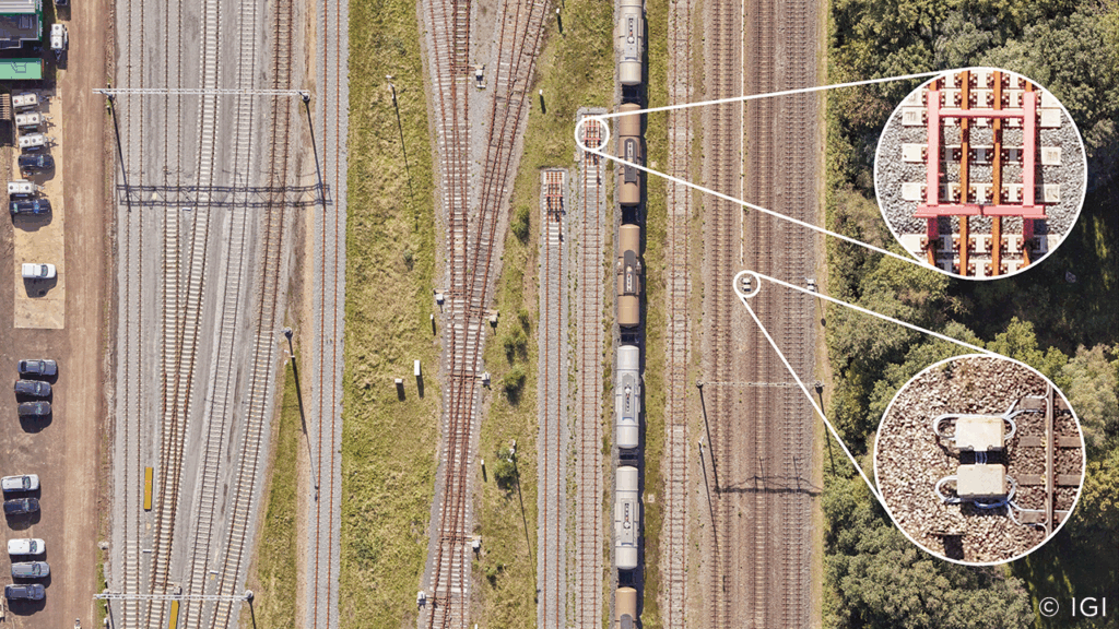
At 1 cm GSD, surface materials, road markings, patches, signage, and small infrastructure elements become clearly distinguishable. “You can tell the difference between brick and asphalt, identify surface conditions, and inspect details that simply aren’t visible at lower resolutions,” Sam explains. “That information is extremely valuable, and you can see it directly from behind your screen.”
This level of clarity benefits both human interpretation and machine learning, enabling more accurate classification, detection, and condition assessment across long corridors.
Efficiency through corridor-focused operations
Traditional strip mapping often captures large areas outside the actual corridor of interest, increasing flight time and data volume. With IGI corridor planning, Kavel 10 can fly missions that closely track linear assets, reducing unnecessary coverage while maintaining required overlap.
Operationally, this translates into shorter flight times, more consistent datasets, and faster delivery—without forcing aggressive maneuvers. When corridors include sharp turns beyond the aircraft limits, missions are segmented and restarted safely, preserving both data quality and operational safety.
From imagery to insight: operationalizing CM-1 data in GIS
High-resolution capture only delivers value when it can be translated into insight at scale. For Kavel 10, CM-1 datasets are designed not just for visualization, but for direct integration into enterprise GIS workflows.
Using Esri reality mapping capabilities, true orthophotos and digital surface models derived from CM-1 imagery become analytical layers—supporting measurement, condition assessment, and AI-assisted feature extraction across long corridors.
“You can’t manage what you can’t measure, and you can’t measure what you can’t see,” explains Arkadiusz (Arek) Szadkowski, Global Sales Manager at Esri. “High-resolution imagery like this becomes a foundational layer in GIS, enabling both traditional analysis and AI-driven workflows—without breaking existing enterprise systems.”
By connecting capture, processing, and GIS into a continuous workflow, Kavel 10 can move faster from data acquisition to actionable insight, while maintaining a single source of truth for stakeholders.
Results: inspection-grade data at fixed-wing scale
By deploying the Phase One + IGI CM-1, Kavel 10 established a new operational baseline for fixed-wing corridor mapping:
- 1 cm GSD achievable at safe operating altitudes
- High forward overlap at real-world aircraft speeds
- Reduced motion blur and strong photogrammetric geometry
- Manageable data volumes and faster processing workflows
The outcome is not just higher-resolution imagery, but more actionable data—ready for inspection, analytics, and future AI-driven applications.
“The future is very bright when you combine the best image quality with professionals who know how to use it,” Sam concludes.
Watch on-demand webinar: Achieve reliable 1 cm corridor data with CM-1
About Phase One
Phase One is a global leader in imaging technology, delivering high-end cameras and imaging solutions for aerial mapping, photogrammetry, and precision measurement workflows.
About IGI
IGI, based in Kreuztal, Germany, is the inventor of Flight Management Systems (CCNS) and advanced positioning and navigation solutions (AEROcontrol) for aerial surveys.
With decades of experience in the geospatial industry, IGI specializes in the design and integration of cutting-edge sensors for both aerial and mobile data acquisition.
Committed to innovation and precision, IGI offers custom-made systems for a wide range of applications, including photogrammetry, LiDAR, thermal and hyperspectral imaging, as well as mobile mapping. The company partners closely with clients around the world – from government agencies to private enterprises – delivering reliable solutions that meet the highest standards of accuracy and efficiency.
IGI’s holistic approach, combining engineering excellence, in-house manufacturing, and expert support, ensures seamless integration and operation across the full data acquisition workflow. From concept to completion, IGI stands for Integrated Geospatial Innovations – Made in Germany.
About Kavel 10
Kavel 10 is a Netherlands-based aerial survey operator delivering high-quality mapping and imagery products across Europe, with a strong focus on resolution, consistency, and operational efficiency. In 2026, Kavel 10 will deliver true orthophoto and oblique imagery covering the entirety of the Netherlands at 3 cm GSD, with the aim of capturing all critical infrastructure at 1 cm resolution.
About Esri
Esri is a global leader in geographic information system (GIS) technology, enabling organizations to visualize, analyze, and manage spatial data at scale. Through its reality mapping capabilities, Esri helps transform high-resolution imagery and surface models into analysis-ready GIS layers that support measurement, inspection, and AI-assisted decision-making across enterprise environments.

Geospatial
Eight perspectives, one system

Geospatial
Finding tiny cracks with UAVs opens new opportunities

Geospatial
From sensors to solutions: How AISPECO orchestrates precision in reality surveying

Geospatial
Monitoring pipeline corridor using PAS 280 large format camera

Geospatial
Preventing Wild Bushfires By Mapping Planned Burns

Geospatial
Novice Aerial Photographer Becomes Advanced Mapping Provider

Geospatial
Inspecting Wind Turbine Blades While They Are Rotating

Geospatial
Precision at Altitude: Redefining Aerial Mapping with the PAS 880 Oblique Camera System

Geospatial
Perfecting telescope dish accuracy with UAV photogrammetry

Geospatial
Saving costs while lowering carbon footprint: Innovative aerial surveying service uses small airplanes enabled by compact cameras

Geospatial
Detecting forest tree diseases using a large-format camera on an ultralight aircraft

Geospatial
Mapping lava flows during volcanic eruptions in Iceland

Geospatial
The PAS Pana: a 48,800-pixel camera innovated with our customer Surdex

Geospatial
Rebuilding after Hawaii’s wildfire with engineering-grade surveying

Geospatial
Revolutionizing Slovenian urban planning: Phase One’s PAS 880i redefines reality mapping