From sensors to solutions: How AISPECO orchestrates precision in reality surveying
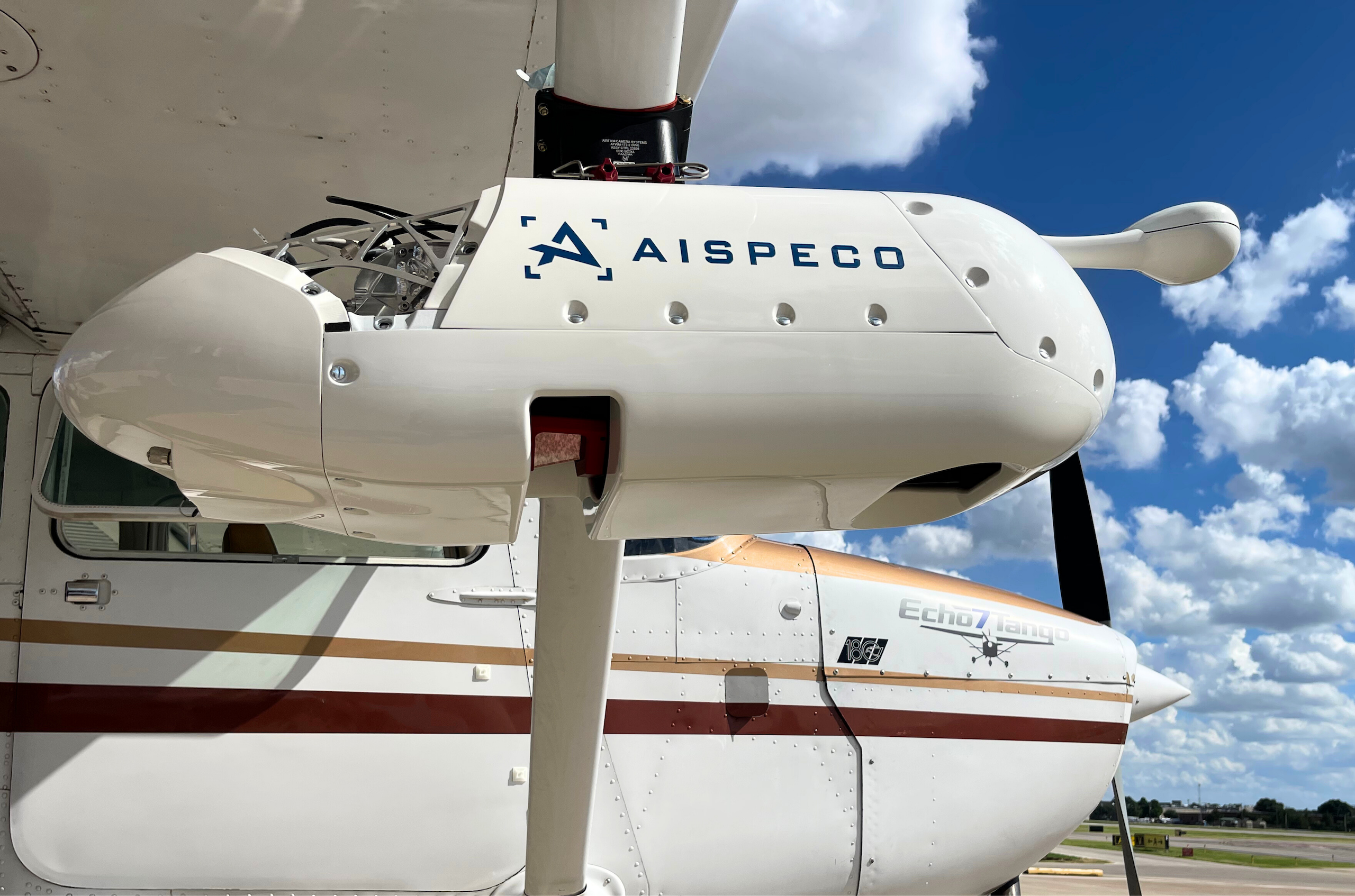
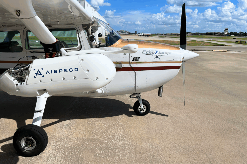
AISPECO’s Heliux LITE
Aerial survey operators often face a trade-off: either invest heavily in dedicated aircraft modifications or settle for lower precision. AISPECO’s Heliux LITE changes that equation – delivering premium data quality without complexity at minimum cost.
Customer Snapshot
Who: DAS Geospatial
Challenge: Expensive and complex aircraft setup
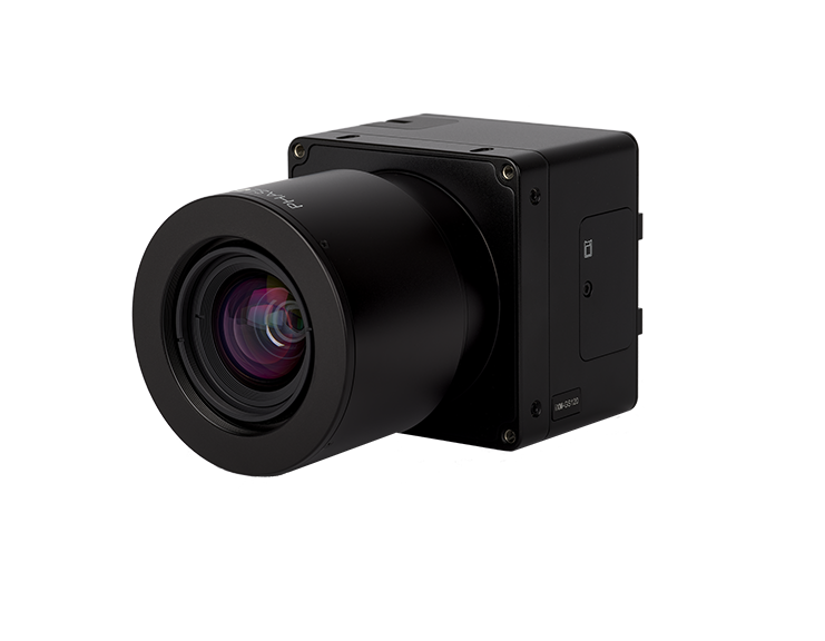
Solution: Heliux LITE + Phase One iXM-GS120
Result: Reduced setup time, improved accuracy, faster delivery
Aerial precision, without aircraft modification
As aerial surveying continues to evolve, the demand for high-quality data, operational efficiency, and adaptable technology grows stronger. Survey companies are seeking solutions that combine precision with economy – systems that integrate seamlessly into existing workflows without the need to own aircraft – meaning no major aircraft modification.
AISPECO redeveloped the Heliux LITE to meet that need: a stabilizer was designed and patented for the next-generation remote-sensing pod designed specifically for light aircraft such as Cessna 172 or Robinson R44 helicopter.
Constructed from lightweight materials and engineered for true modularity, it ensures mechanical stability, geometric precision, and rapid deployment, giving operators a new degree of control in photogrammetric data collection. Internal two-axis stabilizer allows reduction of sidelap and elimination of Y parallax, enabling most complex and large-scale applications.
“Our goal with the Heliux LITE was to make high-end aerial sensing accessible without compromise. Every detail – from the stabilization system to the modular architecture – was built to adapt to the operator, not the other way around,” Rokas Adiklis, CTO, AISPECO.
Modernizing photogrammetry – precision without the pain
Traditional photogrammetry missions – essential for 3D compilation, terrain modeling, and infrastructure visualization – have long depended on camera systems installed through fuselage openings. This conventional setup limits aircraft choice to increase certification complexity and costs, and makes system integration time-consuming.
The Heliux LITE with stabilizer overcomes these limitations with a compact, yaw-stabilized design that enables high-precision photogrammetric imagery, and two-axis stabilized LiDAR data acquisition directly from an external pod.
“Unwanted aircraft motion – particularly on the yaw axis – changes camera heading between frames and can break the epipolar alignment required for manual stereo pair matching,” explains Rokas Adiklis, CTO at AISPECO. “Operators no longer need to worry about data distortion caused by turbulence or crabbing – the Heliux LITE employs an active stabilization system that isolates the sensor array from aircraft crabbing and turbulence, holding a constant look direction. “Yaw and roll stabilization constrain image parallax to a single axis, while LiDAR roll-axis stabilization enables leaner coverage planning with fewer flight lines and significant savings – even on lightweight platforms like the Cessna 172, where traditional gimbals simply can’t be installed.”
This technology directly addresses one of the main challenges in corridor and linear mapping, where aircraft crabbing and atmospheric motion can degrade the accuracy in end products, e.g. point clouds and orthomosaics. The active yaw stabilization ensures a stable corridor of scanning and minimizes the need for excessive side overlap, reducing flight time and cost while improving data integrity.
Seamless sensor synchronization for flawless aerial imaging
The iXM-GS120’s electronic global shutter architecture with market leading shutter speeds of up to 1/16,000 s ensures the finest details are captured even at rapid speeds, which means that even when the aircraft changes heading or the pod undergoes yaw motion, each stereo pair captures perfectly matched geometry. Since the iXM-GS120 uses an electronic global shutter, exposure timing is precise and highly repeatable, which supports consistent capture under dynamic flight conditions — thereby allowing seamless integration with a yaw-stabilized gimbal system. Coupled with tight hardware trigger synchronization (in the tens of microseconds), the sensor fusion maintains consistent and overlap integrity under dynamic flight conditions, resulting in strong image matching that feed straight into photogrammetry workflows.
Proven in the field – real results from real missions
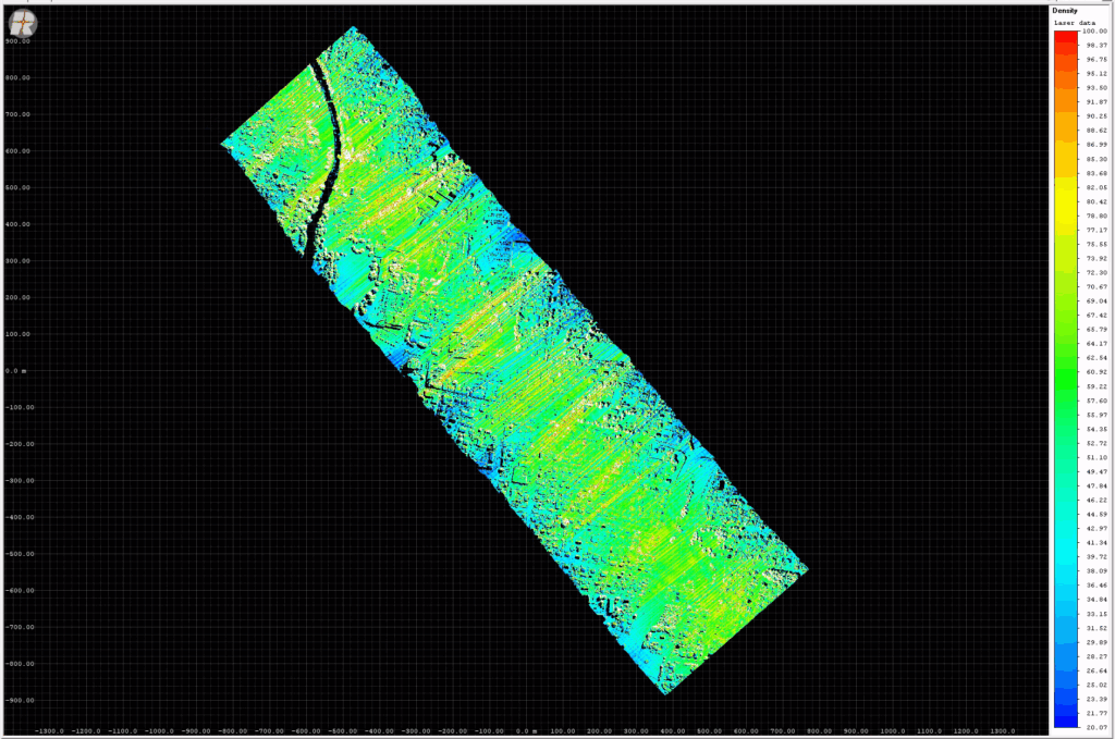
The Heliux LITE has already demonstrated its operational maturity. DAS Geospatial has successfully flown thousands of miles of distribution lines across diverse terrains. “Thanks to the reliable performance of our Heliux LITE system, we were able to progress with confidence that the system would deliver all desired lines and structures as planned,” says Ryan Johnson, VP of Geospatial Technology at DAS Geospatial. “Operators have reported 60% reduction in installation time compared to our other flight systems, while also providing the flexibility to transfer pod seamlessly to various aircraft in our fleet whether it be helicopter or a plane. The Heliux LITE has allowed us to simultaneously collect 5 cm imagery and 30 points/m2 dense LiDAR point cloud, cutting our acquisition time in half, verifying that the system meets the rigorous standards required for large-scale mapping and inspection.”
“At DAS Geospatial, the gimbal stabilized pod has transformed our operations, allowing us to confidently capture extensive distributions networks and transmission corridors over varied environments. This novel integration not only ensures our mapping accuracy is met but also guarantees we deliver precise and reliable results on every project,” comments Ryan Johnson, VP of Geospatial Technology at DAS Geospatial.
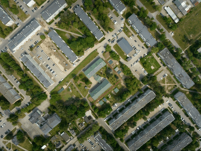
Beyond alignment, the iXM-GS120 scales up wide-area photogrammetric productivity in two major ways: its ultra-high resolution (12,768 × 9,564 pixels) and 80 dB dynamic range capture vast swaths of terrain in a single frame while preserving tonal detail from bright to shadowed terrain. Fewer flight lines are required to cover a target area, reducing inter-strip stitching, overlap variations, and processing complexity. The result is stronger image matching, with high-accuracy and tighter tie-point residual distributions, more efficient bundle-adjustment convergence and better matching ground-control points (GCPs). All these show less scatter across the acquisition area – all contributing to more reliable 3D products, ee.g.,DEMs, meshes and crisp 2D orthomosaics, for repeatable mission-after-mission.
Engineering modularity for real-world use
AISPECO’s development philosophy is rooted in functional modularity and practical engineering. Each component – from the stabilization control unit to vibration isolation – is purpose-built to maintain geometric precision, minimal latency, and field reliability.
The Heliux LITE exemplifies how modular systems can be both powerful and adaptable. Its architecture allows operators to integrate different payload combinations – from high-resolution cameras to LiDAR – within the same stabilized frame, enabling quick reconfiguration between projects.
By working closely with clients such as DAS Geospatial, AISPECO continues to refine its systems to align with real-world survey requirements and operational constraints.
Leveraging cutting-edge aerial technology, the AISPECO team worked with us to customize a camera and LiDAR system which features a two-axis gimbal that dynamically stabilizes unintended roll and yaw motions. This stabilization ensures that our aerial triangulation and orthomosaic processes are more accurate and seamless, resulting in sharper, more reliable mapping data even under challenging flight conditions.
A platform built for the future of aerial surveying
The combination of mechanical stabilization, modular design, and workflow-ready integration defines a new standard for aerial data acquisition.
When paired with advanced aerial imaging systems such as the Phase One iXM-GS120, the result is a fully realized, application-ready aerial platform that enhances the precision, repeatability, and efficiency of professional photogrammetry missions.
“AISPECO’s Heliux LITE is a great example of how smart system integration amplifies sensor performance,” says Thomas Alin, Chief Technology Officer at Phase One. “By synchronizing our iXM-GS120 camera with the pod’s active stabilization system, operators achieve consistent, strong image geometry even in challenging flight conditions. It’s a partnership that turns high-end technology into practically high precision setup, for everyday data acquisition.”
Together, AISPECO and Phase One are redefining what’s possible in aerial mapping – making premium-quality data accessible to more operators, missions, and aircraft than ever before. As both companies continue to innovate, the focus remains clear: to empower survey professionals with tools that simplify operations, improve accuracy, and deliver faster results from the sky to the final map.
About Phase One
Phase One is a global leader in digital imaging technology, providing unrivaled imaging quality for a wide range of applications including professional photography, heritage digitization, industrial inspections, aerial mapping, security, and space.
For more than three decades, Phase One has developed core imaging technologies and a range of digital cameras and imaging modules, setting new standards for image quality in terms of resolution, dynamic range, color fidelity, and geometric accuracy.
Based in Copenhagen, Denmark, Phase One has regional offices strategically located in Denver, Tokyo, Saku, Shanghai and Hong Kong.
Supported by a global sales network, the company nurtures long-term relationships with customers, technology partners, and distributors worldwide, often acting as digital imaging partner to customers with unique requirements. This passion for service ensures Phase One continually exceeds expectations and drives the imaging industry forward.
We deliver Imaging Beyond Imagination.
www.phaseone.com
About AISPECO
AISPECO is a manufacturer of advanced geospatial data collection platforms. Their multi-sensor payloads can be deployed on airborne, mobile, and stationary platforms and combine laser scanning (LiDAR), spectral (hyperspectral) and other imaging capabilities. AISPECO supports surveying, utilities, forestry, city mapping, mining, civil engineering firms, and many other industries across the globe. Their highly customizable hardware solutions cut down overhead costs, including monitoring and surveying operations, by allowing clients to reduce sensor cost, operate more efficiently, and easily change sensors’ configurations and data-collection methods.
AISPECO – Built by surveyors for surveyors.
aispeco.com
About DAS Geospatial
DAS Geospatial is a leading U.S. provider of aerial mapping and geospatial data solutions, delivering precision, innovation, and reliability across a wide range of surveying and remote-sensing applications.
Founded in 1977 in Dallas, Texas, the company has grown from a two-room startup into a technology-driven enterprise that pioneers the adoption of advanced photogrammetry, LiDAR, and UAV-based systems. Family-owned and operated for nearly five decades, DAS Geospatial continues to blend tradition with innovation—serving public and private clients with data that drives confident decision-making.
Headquartered in Addison, Texas, with additional operations in San Antonio, DAS Geospatial is known for its early adoption of digital mapping, softcopy photogrammetry, LiDAR, and sensor-based aerial intelligence. Supported by an experienced team of certified photogrammetrists and mapping scientists, the company upholds a legacy of quality, service, and integrity in every project.
We deliver Precision from the Sky.
dasmaps.com

Geospatial
From capture to corridor intelligence: How Kavel 10 scaled 1 cm mapping with the Phase One + IGI CM-1

Geospatial
Monitoring pipeline corridor using PAS 280 large format camera

Geospatial
Preventing Wild Bushfires By Mapping Planned Burns

Geospatial
Novice Aerial Photographer Becomes Advanced Mapping Provider

Geospatial
Inspecting Wind Turbine Blades While They Are Rotating

Geospatial
Precision at Altitude: Redefining Aerial Mapping with the PAS 880 Oblique Camera System

Geospatial
Perfecting telescope dish accuracy with UAV photogrammetry

Geospatial
Saving costs while lowering carbon footprint: Innovative aerial surveying service uses small airplanes enabled by compact cameras

Geospatial
Detecting forest tree diseases using a large-format camera on an ultralight aircraft

Geospatial
Mapping lava flows during volcanic eruptions in Iceland

Geospatial
The PAS Pana: a 48,800-pixel camera innovated with our customer Surdex

Geospatial
Rebuilding after Hawaii’s wildfire with engineering-grade surveying

Geospatial
Revolutionizing Slovenian urban planning: Phase One’s PAS 880i redefines reality mapping
Geospatial
Imaging solutions combined with AI and 5G – A new approach and promising to assess forest health and detect and monitor wildfires

Geospatial
Phase One Cameras combined with light, fixed-wing aircraft deliver highly efficient LiDAR and mapping missions