Agriculture & Forestry
Using High-Resolution Aerial Thermal Imaging, Multi-sensor Data to Characterize Puerto Rican Forests
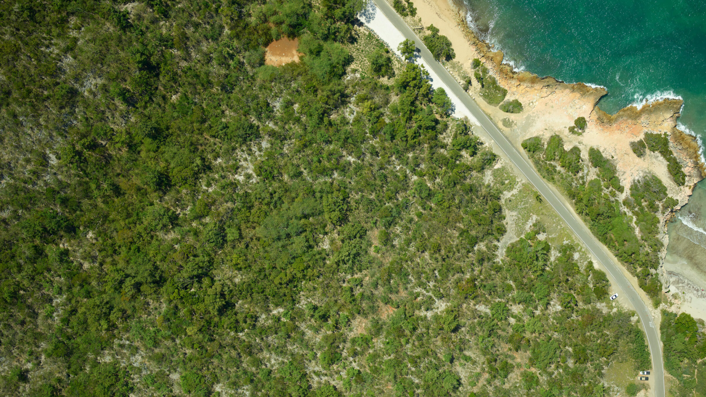
After hurricane deforestation in Puerto Rico, NASA scientists study forest regrowth using high-resolution agriculture aerial imagery and aerial thermal imaging. As a key component of NASA’s G-LiHT system, a 100 megapixel Phase One Industrial camera was used to produce RGB photographs for identification of fine-scale canopy features.
Multiple Sensors Help to Identify Individual Flowers from the Air at 200 mph
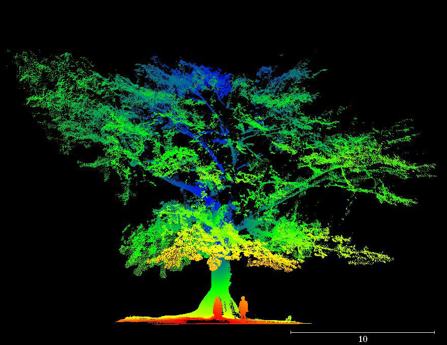
During 2017, NASA launched a project funded by the U.S. Department of Energy to study tropical forest regrowth rates. Ecologists were also interested in the role of tropical forests in terms of sequestering carbon. The project consisted of forest data acquisition through airborne LiDAR, aerial thermal imaging, and image data, as well as ground measurements and terrestrial LiDAR scanning.
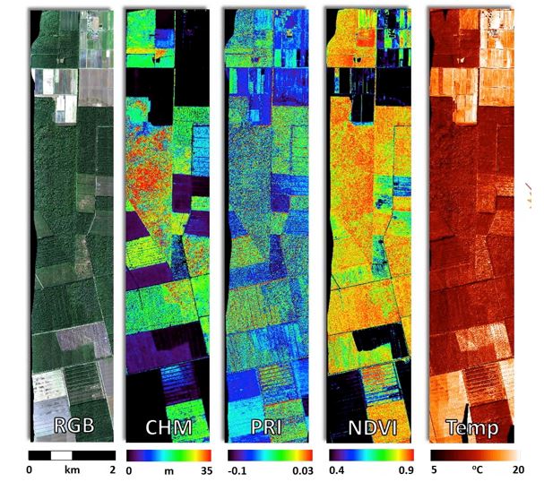
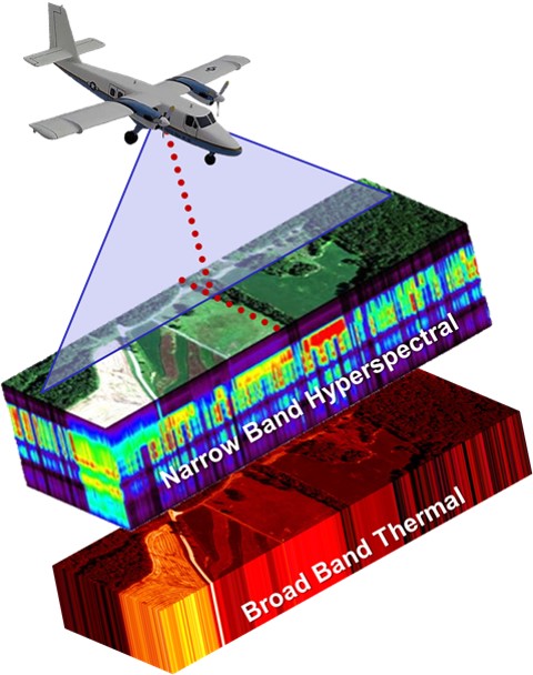
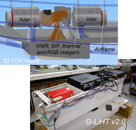
NASA’s G-LiHT is a portable, airborne imaging system that simultaneously maps the composition, structure, and function of terrestrial ecosystems using Dual Scanning RIEGL LiDARs, VNIR Imaging Spectroscopy, Broad Band Aerial Thermal Imaging, High Resolution Aerial Photos using Phase One 100MP, and an Applanix POS AV V6 precision GPS-INS.
Image: G-LiHT simultaneously maps the composition, structure, and function of terrestrial ecosystems using: LiDAR; VNIR Imaging spectroscopy; Thermal measurements; stereo RGB photographs; and Solar-Induced Fluorescence (SIF)
Phase One’s 100MP camera provided the opportunity to develop new algorithmic approaches that can handle large volumes of high-resolution imagery
The African Tulip Tree
Spathodea Campanulata, or African Tulip Tree, is a non-native tree species with orange-colored flowers that occupies much of the island. It is a very effective colonizer following disturbance and abandonment of agricultural land. The researchers were interested in producing maps of the island that showed where the tree was found, and how much forest canopy volume it represented. A combination of airborne LiDAR and optical image data was used, to characterize the tree canopy.
Data collected enables data-fusion studies by providing coincident data in time and space and provides fine-scale (<1m) observations over the large areas that are needed in many ecosystem studies. NASA developed a classification algorithm that can automatically locate the orange flowers in the fine-resolution aerial imagery.
NASA’S G-LIHT (V2.0)
NASA’S Goddard’s LiDAR, Hyperspectral and Thermal Airborne Imager (G-LIHT) uses LiDAR to provide 3D information about the spatial distribution of canopy elements, visible and near infrared (VNIR) imaging spectroscopy to discern species composition, and variations in biophysical variables and thermal measurements to delineate wetlands and to detect heat and moisture stress in vegetation.
Dr. Bruce Cook from NASA explains
“We can better characterize forest ecosystems with multiple sensors as opposed to one killer sensor that does everything. For example, we merged fine-resolution imagery from the Phase One camera with LiDAR data to quantify forest canopy volume that is occupied by Spathodea.”
Intergrated System
The system includes:
- Phase One 100 MP aerial photographs
- Two Riegl scanning LiDARs
- Hyperspec VNIR imaging spectrometer
- SIF imaging spectrometer
- Downwelling irradiance spectrometers
- Thermal infrared camera
- Precision GPS/IMU
Data Acquisition
Airborne data has a finer resolution than satellite imagery taken of the same area. Observations on the ground can be scaled to airborne and satellite data. Moderate- and coarse-resolution satellite data provides a wide-area coverage at greater temporal frequency, but often with less spatial detail.
Approximately 50 flight hours were carried out during 2017. The same areas were re-flown during 2018, following hurricanes Irma and Maria. A user-interactive map available on the G-LiHT website allows data to be viewed and downloaded.
Image: G-LiHT uses lidar to provide 3D information about the spatial distribution of canopy elements, VNIR (visible to near infrared) imaging spectroscopy to discern species composition, and variations in biophysical variables and thermal measurements to delineate wetlands and to detect heat and moisture stress in vegetation.
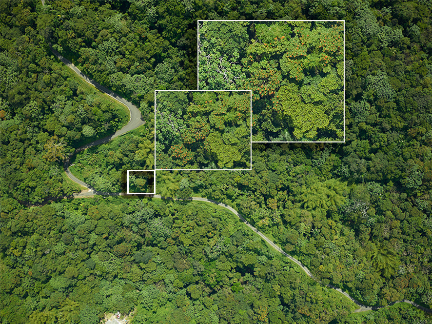
Finding Flowers with Fine-resolution Imagery
Phase One cameras produce high-resolution images with the required 3cm GSD. This made it possible to identify individual flowers within thousands of pixels.
“Identifying trees that may be in decline is important for forest health studies. This project has been an excellent testbed for making tools for detecting insect and disease outbreaks. Being able to characterize forest health conditions over large areas is important for ecosystem monitoring”.
“Phase One’s high-resolution aerial imagery form part of our new digital classification techniques, which open up a whole new territory for NASA,” explains Cook.
Image: Fine-resolution images (~3 cm GSD) where individual flowers can be found in thousands of pixels.

Geospatial
Eight perspectives, one system

Geospatial
Finding tiny cracks with UAVs opens new opportunities

Geospatial
From capture to corridor intelligence: How Kavel 10 scaled 1 cm mapping with the Phase One + IGI CM-1

Geospatial
From sensors to solutions: How AISPECO orchestrates precision in reality surveying

Geospatial
Monitoring pipeline corridor using PAS 280 large format camera

Geospatial
Preventing Wild Bushfires By Mapping Planned Burns

Geospatial
Novice Aerial Photographer Becomes Advanced Mapping Provider

Geospatial
Inspecting Wind Turbine Blades While They Are Rotating

Geospatial
Precision at Altitude: Redefining Aerial Mapping with the PAS 880 Oblique Camera System

Geospatial
Perfecting telescope dish accuracy with UAV photogrammetry

Geospatial
Saving costs while lowering carbon footprint: Innovative aerial surveying service uses small airplanes enabled by compact cameras

Geospatial
Detecting forest tree diseases using a large-format camera on an ultralight aircraft

Geospatial
Mapping lava flows during volcanic eruptions in Iceland

Geospatial
The PAS Pana: a 48,800-pixel camera innovated with our customer Surdex

Geospatial
Rebuilding after Hawaii’s wildfire with engineering-grade surveying

Press Release
Phase One introduces iX Process – a new standard for simplified, high-performance mapping workflows

Press Release
A new benchmark – sub-centimeter aerial mapping at aircraft speeds without compromises

Press Release
A new era in aerial imaging technology – made easy to adopt

Geospatial Blog
Part Two of: Taking Off – our pre-flight checklist for aerial mapping as the season takes off

Press Release
Carbonix, RIEGL, Phase One announce first fixed-wing VTOL integration of long-range dual sensor system

Geospatial Blog
Insights and future trends at Geo Week 2024

Press Release
Phase One Appoints HALG | Hindustan Assistant & Logistic Group as Official Technical Partner in India to Enhance Local Support and Engagement
Press Release
Phase One Introduces PAS Pana at InterGeo 2023: The Most Effective Wide Area Camera for Aerial Mapping

Press Release
Phase One announces New Calibration Lab and Geospatial Center of Excellence in Denver