Dam Inspection
Dam Fine Data:Sub-millimeter-resolutionUAV Dam Surveys by Orthodrone
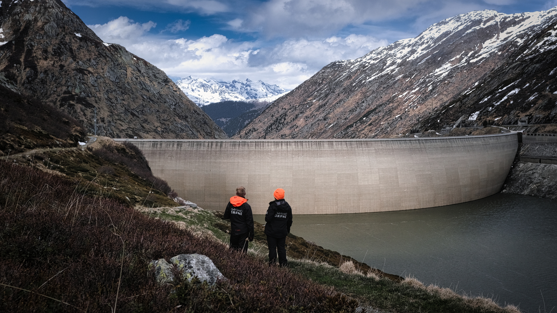
In early 2021, the Orthodrone team crowded themselves and their equipment into a tiny Swiss gondola, making their way to one of two dams scheduled for water-side inspection – no easy feat, given the meters of snow closing off many alpine roads during winter. Often situated in difficult-to-reach locations, Swiss pumped-storage plants can greatly benefit from sub-millimetre-resolution UAV dam surveys. With the appropriate survey-grade, metric sensors, current uncrewed aerial systems (UAV) can offer safer access and increased cost-effectiveness over more traditional inspection methods, while also providing comparable or better data.
Much more than chocolate, knives, and time pieces: Swiss hydropower
Well over half the energy produced in Switzerland comes from hydropower, with Axpo Holding AG as Switzerland’s largest hydropower producer. The canton of Graubünden, where this project took place, contributes over twenty percent of the electricity generated from hydropower in the country, totalling more than 7.9 billion kilowatt hours per year.
Most of the hydropower in Switzerland comes from storage power plants and run-of-river plants, with only 4.3 percent of Swiss hydropower provided by pumped-storage hydropower plants. However, pumped-storage plants are an important piece of a hydropower system, helping to balance supply and demand. In a pumped-storage system, reservoir water is sent through pressure pipes in order to drive turbines, which generate electricity to be fed into the power grid. In addition to providing energy during peak usage, pumped storage plants also allow for the conversion of excess electricity from the grid through the transfer of water from the lower reservoir to the higher reservoir during off-peak periods, making them a vital resource for smoothing energy consumption. Traditionally, water-side inspections of the respective dams tend to cause significant turbine downtime.
image: Low water levels cause turbine downtime, which can be significantly reduced by uncrewed surveys
Swiss dam safety: An internationally recognized regulatory system
Throughout the lifetime of a dam, appropriate operation and consistent maintenance are paramount to minimizing risk. Regular inspection helps to ensure the safety and function of a dam, an area in which Switzerland – highly praised by the International Commission on Large Dams – has excelled, having had no dam failures since 1887. However, conventional dam inspections require resource-intensive data collection by means of workers atop platforms suspended from the dam, providing a prime use case for UAV dam surveys to improve inspection safety and efficiency.
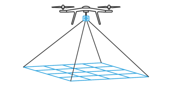
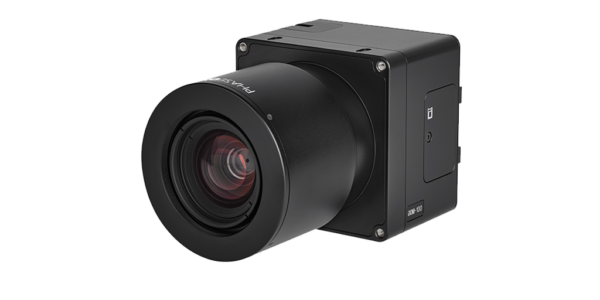
Unlike popular consumer-grade drones, Orthodrone’s equipment includes made-to-measure UAV and metric cameras, made specifically for surveying and inspection. Phase One’s iXM 100 is their favourite tool for photogrammetric data acquisition, allowing the Orthodrone team to get the sub-millimetre resolution data required for a detailed analysis of the safety of a dam. When compared to cameras like the DJI Zenmuse P1, the iXM 100 has not only superior image quality, but also has a faster trigger: within the typical two-second trigger interval for a single shot of the DJI P1, the iXM captures six images – requiring less flight time to capture the necessary data.
With the current setup, the team can achieve a 1.5 mm ground sampling distance (GSD), with a footprint larger than 17 x 13 m, hovering at about 32 m or 60 m away from the dam face (depending on the lens). A 1 mm GSD (footprint roughly 12 x 9 m) is possible at a distance of up to ~40 m away, whereas a 0.5 mm GSD (footprint ≆ 6 x 4.5 m) can be attained up to ~20 m away from the dam wall.
Complete control for sharper images
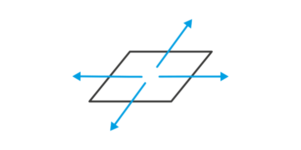
While utilizing a cutting-edge industrial camera considerably enhances productivity, added automation eases the job. No matter which of the UAV is deployed, all of them are equipped with real-time kinematic GNSS, LiDAR-based rangefinders and complete camera setting control, simplifying not only post-processing, but also allowing for sharper images with spot-on focus.
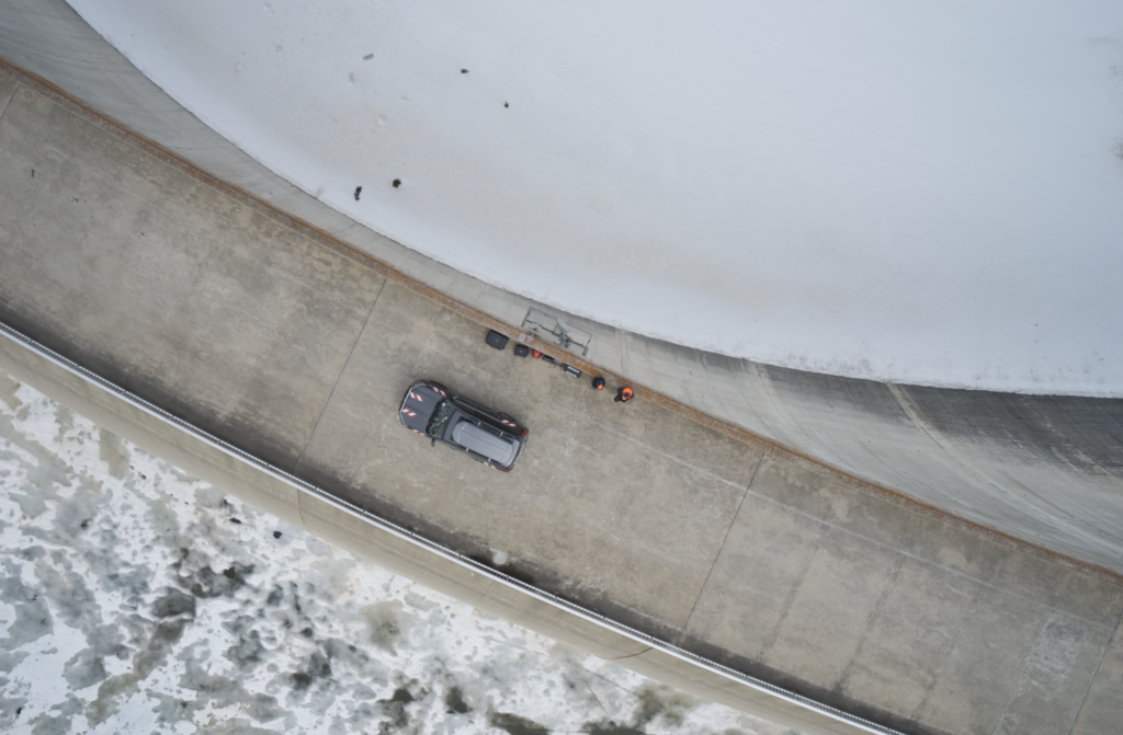
This is particularly important due to the convex shape of most dams, posing challenges for pilots and their spotters, especially during water-side dam surveys in gusty winds. Of the two dams they surveyed, one was 127 m in height with a crest length of 480 m, while the other had a height of 117 m with a crest length of 560 m. Such areas also require terabytes of data storage for the desired (sub-)millimetre resolution of the images, making them a prime use case for our onboard processing units with significantly larger data storage.
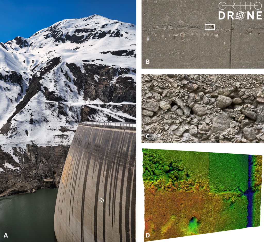
image: A: Survey site | B: Single image (cropped height) | C: Image at 100% zoom | D: Point cloud & analysis | GSD: 0.5 mm/pix
Deliverables – It’s all about perspective
With the gathered images and derived multidimensional deliverables, dam managers can assess the dam face for abnormalities or degradation. Quality data is essential for a thorough assessment of structural integrity. Even miniscule cracks can be detected by sub-millimetre-resolution UAV dam surveying, enabling inspectors to identify areas of concern, which are then properly addressed to mitigate risks before they could progress into more potentially costly and dangerous issues.
Stay tuned for the unveiling of Orthodrone’s new, fully offshore capable, gas-hybrid multi-rotor UAV, which can combine two iXM 100 cameras and a survey-grade Riegl LiDAR, while keeping the entire payload completely stable. Stability is paramount for flying in offshore conditions (or in this case, windy alpine valleys). High wind tolerance means scrubbed missions due to high winds are a thing of the past. The upcoming system will also be able to carry a single, large focal length lens, enabling inspections with half-millimetre resolution from a distance of 40 meters; allowing for a new level of risk management while gathering the best possible data from afar.
About Orthodrone
Orthodrone is your reliable partner for drone-based critical infrastructure inspections – including sub-millimetre photogrammetric dam surveys in hard-to-reach areas. With hours of hover time and top of the line sensors, they are revolutionizing the way all of us gather, process, and utilize spatial data.
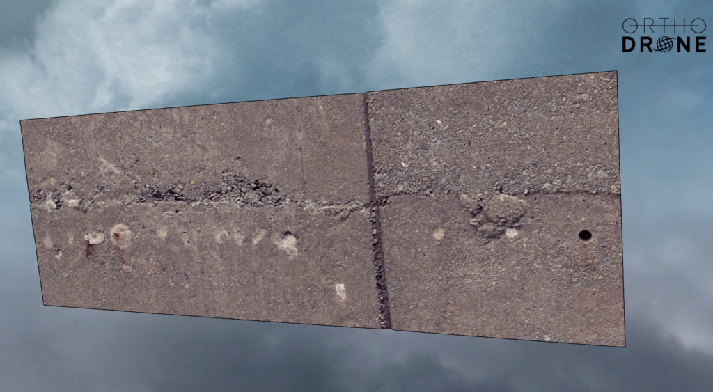
For a closer look at a one of these dams, click the button below to a (slightly decimated) point cloud!

Geospatial
Eight perspectives, one system

Geospatial
Finding tiny cracks with UAVs opens new opportunities

Geospatial
From capture to corridor intelligence: How Kavel 10 scaled 1 cm mapping with the Phase One + IGI CM-1

Geospatial
From sensors to solutions: How AISPECO orchestrates precision in reality surveying

Geospatial
Monitoring pipeline corridor using PAS 280 large format camera

Geospatial
Preventing Wild Bushfires By Mapping Planned Burns

Geospatial
Novice Aerial Photographer Becomes Advanced Mapping Provider

Geospatial
Inspecting Wind Turbine Blades While They Are Rotating

Geospatial
Precision at Altitude: Redefining Aerial Mapping with the PAS 880 Oblique Camera System

Geospatial
Perfecting telescope dish accuracy with UAV photogrammetry

Geospatial
Saving costs while lowering carbon footprint: Innovative aerial surveying service uses small airplanes enabled by compact cameras

Geospatial
Detecting forest tree diseases using a large-format camera on an ultralight aircraft

Geospatial
Mapping lava flows during volcanic eruptions in Iceland

Geospatial
The PAS Pana: a 48,800-pixel camera innovated with our customer Surdex

Geospatial
Rebuilding after Hawaii’s wildfire with engineering-grade surveying
Press Release
Phase One strengthens distribution network with DroneStars for Enhanced UAV Inspection in the Benelux region
Geospatial Blog
Unlocking Efficiency: The Holistic Approach to Drone-Based Utility Inspections
Press Release
Phase One expands distributor reach with Measur for strong UAV inspection growth in the Canadian market
Geospatial Blog
Technology Turning the Tide Against Ocean Plastic Pollution
Geospatial Blog
Setting the New Standard: Evaluating Survey-Grade Accuracy with the Phase One P5
Press Release
Phase One Partners with gNext to Revolutionize Asset Inspections based on Intelligent Image Quality (IIQ)
Geospatial Blog
Part One of: Taking Off – a checklist for the start of the inspection flying season

Geospatial Blog
Insights and future trends at Geo Week 2024

Press Release
Cyberhawk selects Phase One in their pursuit of revolutionizing drone-based industrial inspection by delivering more value in less time.

Press Release
SPH Engineering and Phase One Team Up to Enhance Visual Inspections with ImageInspector Solution

Press Release
Phase One certifies Xer Technologies’ hybrid electric X8 BVLOS capable UAS for next-generation high-resolution inspections

Press Release
Phase One and Boston Announce Partnership for strong Drone Imaging collaboration in the Nordics
Geospatial
Phase One Selects Globe Flight as Sales Partner for Drone Solutions in Germany and Austria
Press Release
Phase One ernennt Globe Flight GmbH als Vertriebspartner für Drohnenlösungen in Deutschland und Österreich
Press Release
Remote Vision Named as Swiss Reseller of Phase One Drone Payloads